Image classification is a critical task in remote sensing that involves categorizing image pixels into distinct classes or categories based on their spectral characteristics. This process is essential in identifying land use, vegetation cover, water bodies, and other features on the earth's surface. Classification is a multi-step process that requires a thorough understanding of the image data, the available classifiers, and the desired output.
To better understand the steps of classification, we will look here at the general steps for supervised classification.
Step 1: Data Mining, aka Finding the Data.
One of the first steps in image classification is data collection, which involves acquiring imagery of the area of interest. The imagery can be obtained from various sources, such as satellites, aircraft, or drones. Once the imagery is obtained, it is essential to preprocess the data to remove any noise and correct for atmospheric effects.
Step 2: Planning your classification approach
After preprocessing the data, the next step is selecting a classifier to classify the pixels into the desired categories accurately. Numerous classification algorithms are available, such as maximum likelihood, support vector machines, random forest, and neural networks. The choice of the classifier depends on the image data's characteristics and the classification task's complexity.
Step 3: Create a Training Sample
Once the classifier is selected, the next step is to train the classifier by creating a training sample. This process involves selecting representative samples from the image data and labeling them according to their corresponding classes. The sample data is then used to train the classifier, and the resulting model can be tested using validation data.
Step 4: Run Classifcation
The final step in image classification is the actual classification of the image data. This process involves applying the trained classifier to the entire image and assigning each pixel to its corresponding class. The resulting classified image can be used for various applications such as land use planning, environmental monitoring, and resource management.
Overall, image classification is a complex and iterative process requiring technical knowledge, domain expertise, and creativity. With the vast array of tools and techniques available in Earth Engine, users can create accurate and detailed classifications that can inform decision-making and promote sustainable development.
Learning Outcomes
- Running a classification in Earth Engine.
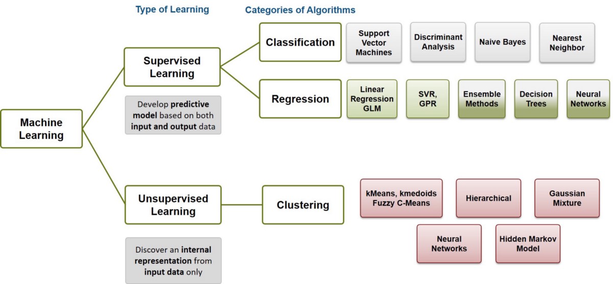
- Understanding the difference between supervised and unsupervised classification.
- Learning how to use Earth Engine geometry drawing tools.
- Learning how to collect sample data in Earth Engine.
- Learning the basics of the hexadecimal numbering system.
This module introduces the concepts of supervised and unsupervised pixel-based classifications and the process of testing different classifiers. Additionally, it covers the concept and application of object-based classification. By understanding these classification techniques, student can generate accurate and useful land cover and land use information that can be utilized in various fields to facilitate informed decision-making and sustainable development.