The three main types of image classification techniques in remote sensing are:
- Unsupervised image classification
- Supervised image classification
- Object-based image analysis
The two most commonly used approaches are unsupervised and supervised classification. However, object-based classification is becoming more popular due to its effectiveness in analyzing high-resolution data.
Unsupervised Classification
Unsupervised classification involves grouping pixels into clusters based on their properties and then classifying each cluster with a land cover class. Overall, unsupervised classification is the most basic technique. Because you don’t need samples for unsupervised classification, it’s an easy way to segment and understand an image.
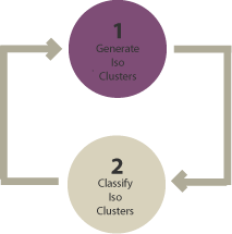
The two basic steps for unsupervised classification are:
- Generate clusters
- Assign classes
Some of the common image clustering algorithms are:
- K-means
- ISODATA
After picking a clustering algorithm, you identify the number of groups you want to generate. For example, you can create 8, 20, or 42 clusters. Fewer clusters have more resembling pixels within groups. But more clusters increase the variability within groups.
To be clear, these are unclassified clusters. The next step is to assign land cover classes to each cluster manually.
Supervised Classification
supervised classification involves selecting representative samples for each land cover class, which the software then uses as training sites to classify the entire image. The three basic steps for supervised classification are selecting training areas, generating signature files, and classifying.
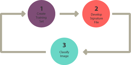
The three basic steps for supervised classification are:
- Select training areas
- Generate signature file
- Classify
For supervised image classification, you first create training samples. For example, you mark urban areas by marking them in the image. Then, you would continue adding training sites representative in the entire image.
You continue creating training samples for each land cover class until you have representative samples for each class. This would generate a signature file, which stores all training samples’ spectral information.
Finally, the last step would be to use the signature file to run a classification. From here, you would have to pick a classification algorithm such as:
- Maximum likelihood
- Minimum-distance
- Principal components
- Support vector machine (SVM)
- Iso cluster
Object-Based Image Analysis (OBIA)
Object-based image analysis differs from the pixel-based approach in supervised and unsupervised classification. It groups pixels into representative vector shapes with size and geometry. The steps for object-based image analysis classification include performing multiresolution segmentation, selecting training areas, defining statistics, and classifying. Object-based classification is particularly useful for analyzing high-resolution data.
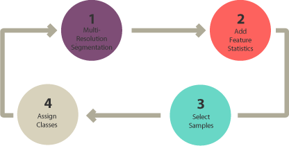
Here are the steps to perform object-based image analysis classification:
- Perform multiresolution segmentation
- Select training areas
- Define statistics
- Classify
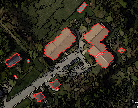
Object-based image analysis (OBIA) segments an image by grouping pixels. It doesn’t create single pixels. Instead, it generates objects with different geometries. If you have the right image, objects can be so meaningful that it does the digitizing for you. For example, the segmentation results below highlight buildings.
The two most common segmentation algorithms are:
- Multi-resolution segmentation in eCognition
- The segment mean shift tool in ArcGIS
In Object-Based Image Analysis (OBIA) classification, you can use different methods to classify objects. For example, you can use the following:
SHAPE: If you want to classify buildings, you can use a shape statistic such as “rectangular fit”. This tests an object’s geometry to the shape of a rectangle.
TEXTURE: Texture is the homogeneity of an object. For example, water is mostly homogeneous because it’s mostly dark blue. But forests have shadows and are a mix of green and black.
SPECTRAL: You can use the mean value of spectral properties such as near-infrared, short-wave infrared, red, green, or blue.
GEOGRAPHIC CONTEXT: Objects have proximity and distance relationships between neighbors.
NEAREST NEIGHBOR CLASSIFICATION: Nearest neighbor (NN) classification is similar to supervised classification. After multi-resolution segmentation, the user identifies sample sites for each land cover class. Next, they define statistics to classify image objects. Finally, the nearest neighbor classifies objects based on their resemblance to the training sites and the statistics defined.
This content is adapted from: https://gisgeography.com/image-classification-techniques-remote-sensing/