At a Glance
At a Glance
Learning Outcomes
- Remember: Identify Europe's physical boundaries, major peninsulas, and key landforms.
- Understand: Explain the influence of the Gulf Stream and landforms on human settlement.
- Analyze: Examine centripetal and centrifugal forces shaping the European Union (EU).
- Evaluate: Assess the challenges of supranationalism (Brexit, migration, economic disparity).
- Analyze: Compare the development of nation-states and the current cultural mosaic.
Key Terms
Supranationalism, Peninsula of Peninsulas, Gulf Stream, Blue Banana, Schengen Area, Devolution, Centripetal Forces, Centrifugal Forces.
Stop & Check
Reveal Answer
Common Misconception
Myth: The European Union is a single country like the USA.
Fact: The EU is a supranational organization of sovereign states. Member countries pool some sovereignty (like trade) but retain independence in many others (like military).
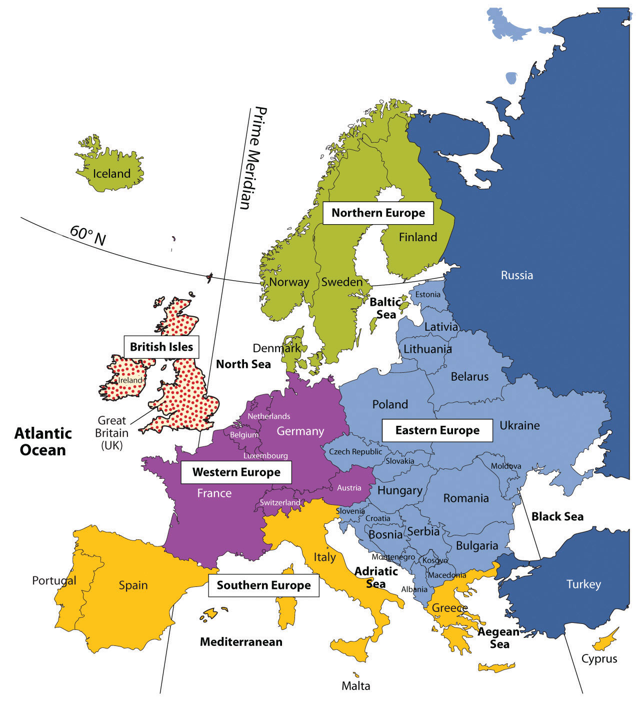
Regional Snapshot: Europe at a Glance
Europe is often described as a peninsula of peninsulas. Its geography is defined by its deep relationship with the sea, which has historically facilitated trade, exploration, and the spread of ideas. Despite its small land area compared to other regions, Europe's impact on global systems - from industry to law - is profound.
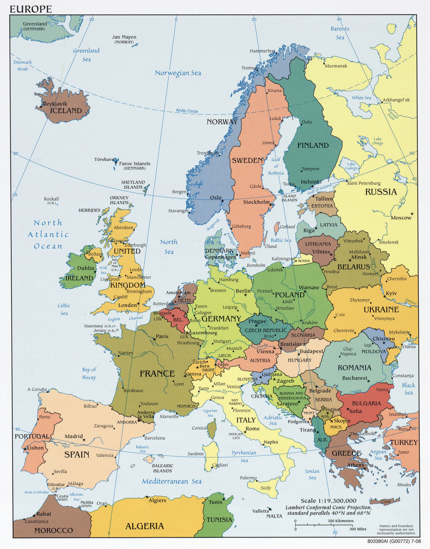
Interactive Map: The European Peninsula
Explore the physical and political boundaries of Europe. Zoom in to see how mountains like the Alps and rivers like the Rhine have influenced the growth of major urban centers.
Use the layer control to toggle between Physical terrain and Political boundaries. Notice the high density of urban nodes in the "Blue Banana" corridor from London to Milan.
Physical Geography: Landforms and Climate
Europe's landforms cluster into four major regions, each shaping human activity in distinctive ways. Understanding these physical foundations helps explain why Europe developed as the birthplace of the Industrial Revolution and remains a center of global economic activity.
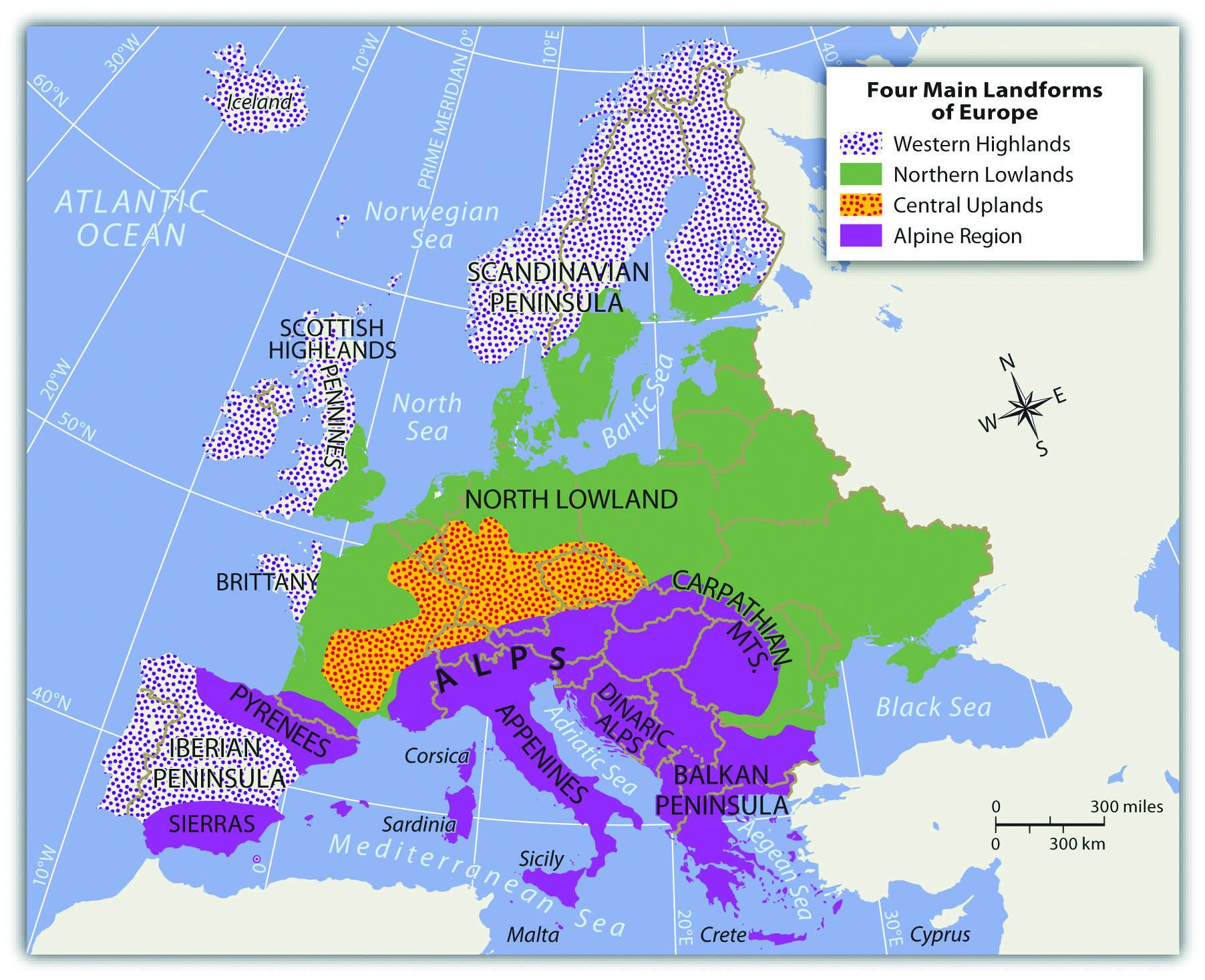
The Four Main Landform Regions
1. The Alpine Region
The High Alps range from eastern France to Slovenia and include several related mountain systems:
- The Pyrenees, form the natural border between France and Spain
- The Apennines, run the length of the Italian peninsula
- The Carpathians, loop around Romania from Slovakia
- The Dinaric Alps, extend through the former Yugoslavia
Mountains historically isolated communities, leading to distinct cultural groups. Today, the Alps are a major tourism hub, Switzerland alone earns billions annually from ski resorts and Alpine tourism.
2. The Northern Lowlands (European Plain)
This great plain extends from southern France through Germany and all the way to the Ural Mountains in Russia. Like the American Midwest, it serves as Europe's "breadbasket" with excellent agricultural soils. The region's flat terrain has also made it a historical invasion corridor, armies from Napoleon to Hitler used it to move rapidly across the continent.
3. The Central Uplands
The foothills of the Alps stretching across southern Germany are rich in natural resources, coal, iron ore, and timber, that fueled the Industrial Revolution. Today, this region remains Europe's manufacturing heartland, home to German automotive giants like BMW, Mercedes-Benz, and Volkswagen.
4. The Western Highlands
These rugged, ancient mountains include the Scottish Highlands, the Welsh mountains, and portions of Scandinavia. Less suitable for agriculture, these regions support grazing livestock and forestry. The Pennines in England powered early textile mills with hydropower before coal mining became dominant.
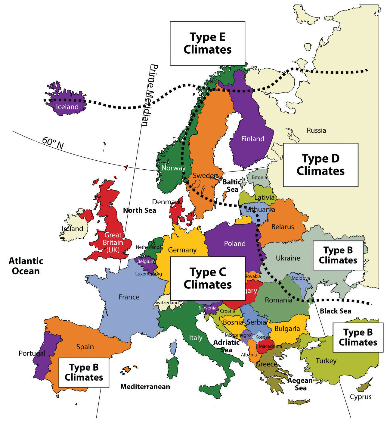
The Climate Advantage: The Gulf Stream
Europe's climate is remarkably moderate for its northern latitude. Paris is at the same latitude as Fargo, North Dakota, yet enjoys a much milder climate. The secret is the Gulf Stream (North Atlantic Drift).
This powerful ocean current carries warm water from the Gulf of Mexico across the Atlantic, acting as an "oceanic radiator" that warms Western Europe. This allows:
- Year-round agricultural productivity in Western Europe
- Ice-free ports along Norway's Arctic coast
- Mediterranean climates that support olives, grapes, and citrus
- Dense population settlement at latitudes that would otherwise be challenging
Rivers: Europe's Transportation Network
Two major rivers divide Europe and have served as critical transportation corridors for millennia:
- The Rhine, flows from Switzerland north through Germany to Rotterdam, one of the world's busiest ports
- The Danube, flows from Germany east through Vienna, Budapest, and Belgrade to the Black Sea
These rivers, combined with Europe's extensive coastlines, meant that most of the continent was accessible by water, a crucial advantage for trade and economic development.
Geographic Inquiry
Scientists warn that Arctic ice melt could disrupt the Gulf Stream by adding fresh water to the North Atlantic, slowing the current's circulation. How might the weakening or collapse of the Gulf Stream affect: (1) Europe's agricultural productivity, (2) population distribution, and (3) the global economy?
Important Person
Architect of European Integration
Jean Monnet never held elective office, yet he is known as the "Father of Europe." He pioneered the idea of supranationalism, believing that by merging the coal and steel industries of former enemies, war would become "not only unthinkable but materially impossible."
Learn more about the Monnet Plan →Human Geography: The Cultural Mosaic
Europe is one of the world's most urbanized and densely populated regions. Its cultural landscape is a mosaic of languages and religions, often reflecting centuries of migration and shifting political borders.
Linguistic Diversity
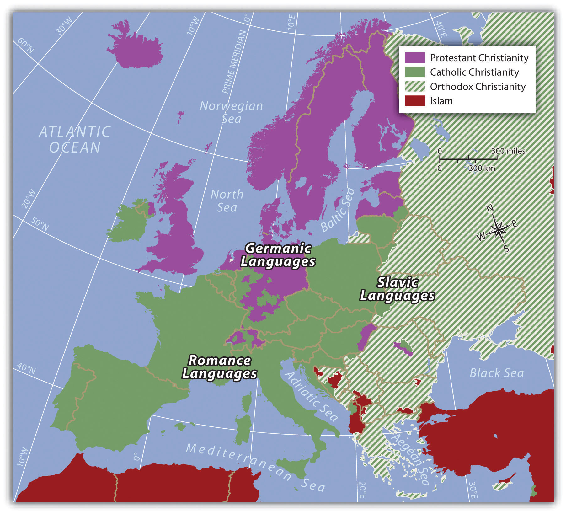
Despite its small size, Europe contains remarkable linguistic diversity. The major language families include:
- Germanic Languages: English, German, Dutch, and Scandinavian languages (Norwegian, Swedish, Danish)
- Romance Languages: Spanish, French, Italian, Portuguese, and Romanian, all descended from Latin
- Slavic Languages: Russian, Polish, Czech, Slovak, Serbian, Croatian, Bulgarian, and Ukrainian
Some languages fall outside these major families entirely: Hungarian (Uralic), Finnish and Estonian (Finno-Ugric), Basque (language isolate with no known relatives), and Greek (its own Indo-European branch).
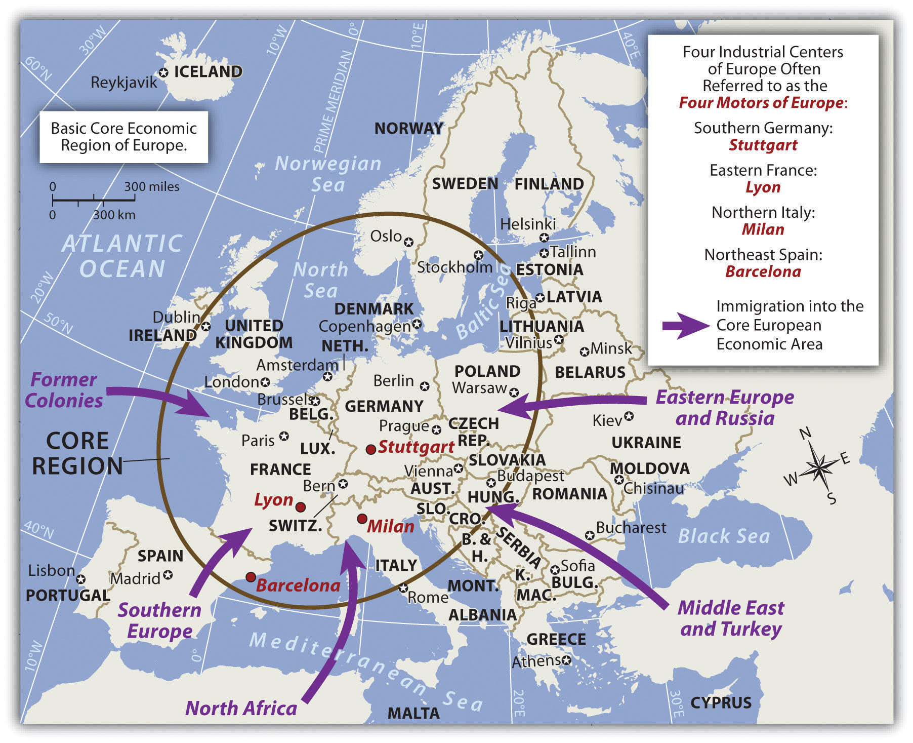
The "Blue Banana" and Urban Development
Geographers have identified Europe's economic core as the "Blue Banana", a crescent-shaped megalopolis stretching from Manchester and London through the Rhine Valley to Milan. This corridor contains:
- Over 110 million people
- Europe's highest concentration of industry and services
- Major transportation hubs including Rotterdam, Frankfurt, and Brussels
- Per capita incomes significantly above the European average
Demographic Challenges
Europe faces a profound demographic challenge: an aging population combined with low birth rates. Several countries have fertility rates well below the replacement level of 2.1:
- Italy: 1.24 children per woman
- Spain: 1.19 children per woman
- Germany: 1.53 children per woman
This demographic shift creates pressure on pension systems, healthcare, and labor markets, driving debates about immigration policy.
Migration and Identity
Migration has reshaped Europe's cultural landscape. The 2015 refugee crisis, primarily from Syria, Afghanistan, and Iraq, brought over one million asylum seekers to Germany alone. This migration has sparked political debates about:
- Integration and multiculturalism
- The relationship between national identity and European identity
- The economic contributions vs. costs of migration
- The rise of nationalist political movements
Historical Perspective: From Empire to Nation-State
Modern European borders largely emerged from the collapse of three empires after World War I: the Austro-Hungarian Empire, the Ottoman Empire, and the German Empire. Many contemporary conflicts, from the Balkans to Ukraine, have roots in these imperial legacies and the ethnic boundaries drawn in their aftermath.
The European Union: Supranationalism in Action
The European Union (EU) represents humanity's most ambitious experiment in supranational governance, the voluntary transfer of sovereignty from nation-states to a transnational organization. Understanding the EU is essential to understanding modern Europe.
Origins: From Coal and Steel to Economic Union
The EU's origins lie in the aftermath of World War II. French diplomat Jean Monnet believed that by integrating the coal and steel industries of former enemies, war would become "not only unthinkable but materially impossible." This led to:
- 1951: European Coal and Steel Community (ECSC), France, West Germany, Italy, Belgium, Netherlands, Luxembourg
- 1957: Treaty of Rome creates the European Economic Community (EEC)
- 1992: Maastricht Treaty transforms the EEC into the European Union
- 2002: The Euro currency launches in 12 countries
- Today: 27 member states (after UK's 2020 departure)
Key EU Institutions
How the EU Works
- European Commission (Brussels): The EU's executive branch, proposes legislation and enforces treaties
- European Parliament (Strasbourg): Directly elected by EU citizens, approves legislation and budgets
- European Council (Brussels): Heads of government set overall political direction
- European Court of Justice (Luxembourg): Interprets EU law and ensures uniform application
- European Central Bank (Frankfurt): Manages monetary policy for Eurozone countries
The Schengen Area: Borderless Europe

The Schengen Agreement (1985) created a zone of free movement across 27 European countries. Within this area:
- No passport controls at internal borders
- Common visa policy for non-EU visitors
- Coordinated external border security
Not all EU members are in Schengen (Ireland maintains border controls), and some non-EU countries participate (Switzerland, Norway, Iceland).
Centripetal vs. Centrifugal Forces
Geographers analyze political integration through the lens of centripetal forces (factors that bind together) and centrifugal forces (factors that pull apart):
| Centripetal Forces | Centrifugal Forces |
|---|---|
| Shared currency (Euro) | Linguistic diversity (24 official languages) |
| Freedom of movement (Schengen) | Uneven economic development (North vs. South) |
| Common market and trade rules | Nationalism and Euroskepticism |
| Shared democratic values | Debates over sovereignty and immigration |
| Peace and stability since WWII | Brexit and potential exits |
Geographic Inquiry
The EU has been remarkably successful at preventing war between member states, a region that experienced two devastating world wars in the 20th century. Could this model of economic integration leading to political stability work in other conflict-prone regions like the Middle East or East Asia? What geographic and cultural factors would make it easier or harder?
Natural Resources and Environmental Concerns
Europe's natural resources powered the Industrial Revolution, but intensive exploitation has created significant environmental challenges.
Natural Resources
- Coal: Once abundant in Britain, Germany, Poland, and Ukraine; largely depleted and declining due to environmental concerns
- North Sea Oil and Gas: Tapped since the 1970s by Norway, UK, Denmark, Netherlands, and Germany, now half depleted
- Iron Ore: Found in Sweden, France, and Ukraine, crucial for steel production
- Fisheries: The North Atlantic provides 10% of global fish catches, but stocks are declining due to overfishing
- Forests: Cover 40% of Europe's land area, with extensive replanting programs since 2000
Environmental Challenges
- Acid Rain: Industrial pollution from Central Europe damages forests and lakes in Scandinavia
- Air Quality: Major cities face pollution from vehicles and industry
- Overfishing: Atlantic cod and bluefin tuna stocks are severely depleted
- Climate Change: Southern Europe faces drought and heat waves; Alpine glaciers are retreating
The European Green Deal
In 2019, the EU launched the European Green Deal, aiming to make Europe the first climate-neutral continent by 2050. Key targets include: 55% reduction in greenhouse gas emissions by 2030, €1 trillion in sustainable investments, and binding requirements for renewable energy in all member states.
Brexit and the Geography of Sovereignty
The United Kingdom's departure from the EU (Brexit) serves as a powerful example of centrifugal forces - factors that pull a region apart. This decision wasn't just political; it was geographic, impacting trade routes, fishing rights, and the status of the border on the island of Ireland.
Questions to Consider:
- How did the "perceptual geography" of the UK differ between urban London and rural northern England during the Brexit vote?
- What are the implications of a "hard border" for functional regions that cross international boundaries?
- Alpine Region
- Europe's major mountain system including the Alps, Pyrenees, Apennines, Carpathians, and Dinaric Alps.
- Blue Banana
- A crescent-shaped megalopolis stretching from Manchester through the Rhine Valley to Milan, containing Europe's economic core.
- Brexit
- The United Kingdom's withdrawal from the European Union, completed on January 31, 2020.
- Centrifugal Forces
- Factors that divide or pull apart a state or region, such as ethnic conflict, linguistic divisions, or economic inequality.
- Centripetal Forces
- Factors that bind a state or region together, such as a shared language, strong economy, or unifying national symbols.
- Central Uplands
- The foothills of the Alps in southern Germany, rich in coal, iron ore, and timber that fueled industrialization.
- Danube River
- Europe's second-longest river, flowing from Germany through Vienna, Budapest, and Belgrade to the Black Sea.
- European Union (EU)
- A supranational organization of 27 European countries promoting economic and political integration.
- Eurozone
- The 20 EU member states that have adopted the Euro as their official currency.
- Gulf Stream
- A warm ocean current that flows from the Gulf of Mexico across the Atlantic, moderating Western Europe's climate.
- Northern Lowlands (European Plain)
- The great plain extending from France through Germany to the Ural Mountains, serving as Europe's agricultural heartland.
- Rhine River
- A major European river flowing from Switzerland through Germany to Rotterdam, the Netherlands.
- Schengen Area
- A zone comprising 27 European countries that have abolished passport controls at their mutual borders.
- Supranationalism
- A system where three or more countries share authority by transferring some sovereignty to achieve common goals.
- Western Highlands
- Ancient, rugged mountain regions in Scotland, Wales, and Scandinavia, less suitable for agriculture but rich in resources.
- Peninsula of Peninsulas: Europe's extensive coastlines and deep relationship with the sea facilitated trade, exploration, and the spread of ideas throughout history.
- Four Landforms: The Alpine Region, Central Uplands, Northern Lowlands, and Western Highlands each shaped human settlement and economic development in distinct ways.
- Climate Advantage: The Gulf Stream gives Western Europe a remarkably moderate climate for its northern latitude, enabling year-round agriculture and dense population settlement.
- Cultural Mosaic: Three major language families (Germanic, Romance, Slavic) and centuries of migration created Europe's rich but sometimes contentious cultural diversity.
- Supranational Integration: The EU represents history's most ambitious experiment in voluntary sovereignty transfer, creating economic union and free movement across borders.
- Centripetal vs. Centrifugal: Europe demonstrates both unifying forces (shared currency, open borders, economic cooperation) and dividing forces (nationalism, linguistic diversity, uneven development).
- Demographic Challenge: Aging populations and low birth rates create pressure on pension systems and drive debates about immigration policy.
- Environmental Pressures: Industrial heritage has left environmental challenges including depleted fisheries, acid rain, and climate change impacts.
Should a New Country Join the EU?
You are a delegate at the European Council. A new Eastern European country has applied for EU membership. It has a young democracy, a struggling economy, and a large population eager for opportunity, but it also has high corruption levels and ongoing border disputes with a neighbor.
Role A: Germany (Net Contributor)
You pay more into the EU budget than you receive. You worry about the cost of supporting a poorer new member, but you also value expanding the single market.
Role B: Poland (Recent Member)
You joined the EU in 2004 and benefited enormously from EU development funds. You strongly support enlargement as a path to stability and prosperity.
Role C: France (Sovereignty Advocate)
You are cautious about further enlargement. You believe the EU must deepen integration among existing members before expanding, and you worry about immigration flows.
Role D: The Applicant Country
You see EU membership as your path to economic development, democratic stability, and security. You are willing to implement difficult reforms to qualify.
Data Exploration: Europe's Demographic Divide
Europe's aging population crisis is unevenly distributed. Compare total fertility rates (children per woman) across major European nations. The replacement rate of 2.1 is shown as a reference line, any country below it faces long-term population decline without immigration.
Interpretation: Notice how Southern European nations (Italy, Spain) have the lowest fertility rates, while France and Ireland are closer to replacement level. How does this demographic data connect to debates about immigration policy and the future of the EU's workforce?
Discussion and Reflection Prompts
Reflect on Your Learning
- Geographic Boundaries: Why is it difficult to define Europe's eastern boundary? How might this geographic ambiguity affect political relationships today?
- Supranationalism: What are the advantages and challenges of surrendering some national sovereignty to a supranational organization like the EU?
- Physical Geography & Development: How have mountains, rivers, and access to the sea shaped where Europeans have settled and built their economies?
Discuss With Your Peers
- Could the EU model of integration work in other regions of the world? What geographic, cultural, or economic factors would need to be different?
- The North Atlantic Drift keeps Western Europe temperate. What would happen to migration and settlement patterns if this ocean current were disrupted by climate change?
- Brexit is an example of centrifugal forces pulling a region apart. What geographic factors might prevent other countries from leaving the EU?
Knowledge Check
Test your understanding of the core concepts covered in this chapter. This quiz consists of multiple-choice questions designed to review key terms, regional patterns, and geographic relationships. Select the best answer for each question to receive immediate feedback.
Loading quiz questions...
Curriculum Standards Alignment
This chapter aligns with the following National and State geography standards.