At a Glance
At a Glance
Learning Outcomes
- Understand: Describe the physical challenges of permafrost, continentality, and vast distances.
- Understand: Summarize the enduring legacy of the Soviet Union (Russification, Command Economy).
- Analyze: Examine Russia's role as a "Petro-State" and energy geopolitics.
- Evaluate: Assess the geographic roots of the Ukraine conflict and "Near Abroad" policies.
- Analyze: Compare the development paths of the five Central Asian "Stans."
Key Terms
Permafrost, Taiga, Russification, Command Economy, Oligarchs, Near Abroad, Landlocked, Resource Curse, Aral Sea Disaster.
Stop & Check
Reveal Answer
Common Misconception
Myth: Russia is always freezing cold everywhere.
Fact: Russia has extreme continentality. While winters are brutal, summers can be sweltering (reaching 100F). The climate varies wildly by season.
Regional Profile
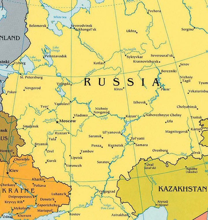
Interactive Map: Russia and Central Asia
Physical Geography
Major Physical Regions
Russia's vast territory encompasses extraordinary physical diversity. Understanding these regions is essential for grasping why Russia developed as it did, and the challenges it faces today.
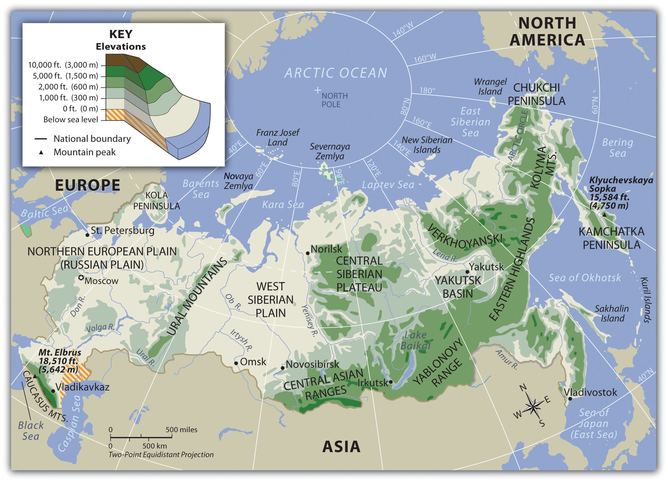
The Russian Plain (European Russia): Western Russia consists of flat to rolling terrain extending from the western borders to the Ural Mountains. This region contains the agricultural heartland, major rivers (Volga, Don), and the vast majority of Russia's population, about 80% of Russians live in this zone despite it comprising only 25% of the territory. Moscow sits at the center of this plain, and its position allowed the city to become the collection point for river-borne trade. The Volga River, Europe's longest, flows 2,300 miles from northwest of Moscow to the Caspian Sea.
The Ural Mountains: These ancient, eroded mountains (averaging only 6,000 feet) form the traditional boundary between Europe and Asia. Rich in minerals including iron, copper, bauxite, and precious metals, the Urals were critical to Soviet industrialization. Cities like Magnitogorsk were built specifically to exploit these resources.
Siberia: The vast eastern region between the Urals and the Pacific contains three sub-regions:
- West Siberian Plain: One of the world's largest flatlands, containing enormous oil and gas deposits beneath frozen marshes
- Central Siberian Plateau: Rich in mineral wealth including diamonds, gold, and nickel
- Russian Far East: The Pacific coast region, closest to Japan and China, containing the major port of Vladivostok
Lake Baikal, located in Siberia, deserves special mention, it is the world's oldest (25 million years) and deepest (1.6 km) lake, containing 20% of the world's surface fresh water.
Central Asia: The five "-stan" countries (Kazakhstan, Uzbekistan, Turkmenistan, Kyrgyzstan, Tajikistan) feature arid steppes and deserts in the lowlands, with the Tian Shan and Pamir mountains along southern borders. The Aral Sea, once the world's fourth-largest lake, has shrunk to about 10% of its original size due to Soviet-era irrigation projects diverting the Amu Darya and Syr Darya rivers for cotton cultivation, one of history's greatest environmental disasters.
Climate and Vegetation
Russia's climate reflects its vast size and continental position. Type D (continental) climates dominate, characterized by extreme temperature variations:
- Extreme continentality: Verkhoyansk in Siberia holds the record for the coldest temperature outside Antarctica (-90F) while summer temperatures can reach 100F, a 190F annual range
- Permafrost: Permanently frozen ground underlies about 65% of Russian territory, extending to depths of 1,500 meters in some areas
- Short growing season: Most of Russia has fewer than 150 frost-free days, making agriculture challenging
Vegetation Zones
Russia's vegetation zones form distinct east-west bands:
- Tundra: Arctic coastal zone with permafrost, lichens, and mosses, too cold for trees
- Taiga: The world's largest biome, covering 60% of Russia, a vast boreal forest of spruce, fir, and larch
- Mixed Forest: Transition zone in western Russia with deciduous and coniferous trees
- Steppe: Grasslands of southern Russia and Central Asia, historically home to nomadic peoples
- Desert: Arid zones in Central Asia, including the Kyzylkum and Karakum deserts
Important Person
Last Leader of the Soviet Union
Mikhail Gorbachev became General Secretary of the Communist Party in 1985, inheriting a stagnating economy and a rigid political system. He introduced two transformative policies: glasnost (openness), which loosened censorship and allowed public debate, and perestroika (restructuring), which attempted to modernize the Soviet command economy by introducing limited market mechanisms. Gorbachev intended these reforms to strengthen the Soviet Union, but they inadvertently unleashed forces that dismantled it. Nationalist movements surged across the 15 Soviet republics, and by December 1991 the USSR had dissolved into independent states. His policies reshaped the political geography of an entire continent, creating 15 independent nations from one superpower. Gorbachev received the Nobel Peace Prize in 1990 for his role in ending the Cold War without direct military confrontation between the superpowers.
Learn more about Gorbachev's legacy →The Soviet Legacy
The Union of Soviet Socialist Republics (USSR, 1922-1991) profoundly shaped this region's geography, economy, and politics. Understanding the Soviet legacy is essential for comprehending current conditions and ongoing conflicts.
The Russian Empire: Expansion and Russification
Before the Soviet era, the Russian Empire gradually expanded from its core around Moscow. By the end of the 19th century, Russian czars had accumulated territory stretching from Poland to Alaska, from the Arctic to Central Asia. The empire used Russification, promoting Russian language, culture, and Orthodox Christianity, to try to assimilate diverse populations. This policy was only partially successful; millions of Muslims, Buddhists, and speakers of non-Russian languages maintained their identities.
Formation of the Soviet Union
The Soviet Union emerged from the 1917 Russian Revolution and Civil War. The Communists reorganized the empire into Soviet Socialist Republics (SSRs) based on ethnic nationality:
- 15 SSRs formed, each named for a dominant ethnic group (Russian, Ukrainian, Uzbek, etc.)
- In theory, each republic was voluntarily allied with the USSR; in practice, Moscow controlled all
- The Soviet system actually created some national identities that hadn't existed before (Uzbek, Kazakh, Turkmen)
Why This Matters Today
When the USSR collapsed in 1991, these administrative boundaries became international borders. The Soviet practice of scattering ethnic Russians throughout the empire left Russian minorities in every newly independent state, a key factor in conflicts like the 2022 Ukraine war.
Industrialization and the Command Economy
Soviet central planners rapidly industrialized the country through Five-Year Plans:
- Collectivized agriculture replaced private farming (causing devastating famines in Ukraine and elsewhere)
- Heavy industry prioritized over consumer goods
- Factory cities built in Siberia and the Urals to exploit resources far from potential invasion routes
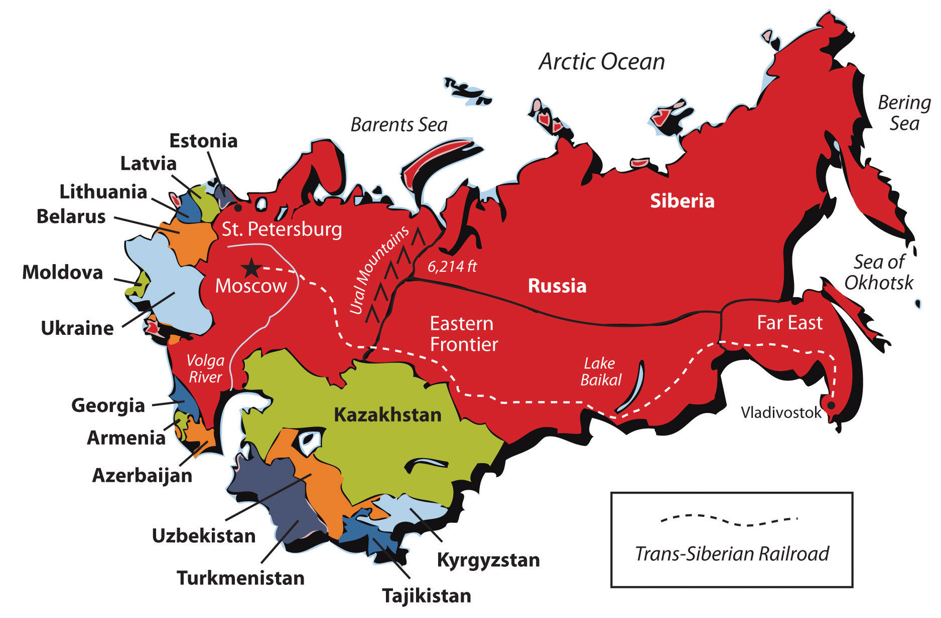
- The Trans-Siberian Railway (the world's longest railway line at 5,772 miles) connected Moscow to Vladivostok
- New "closed cities" built around secret nuclear and military facilities
Collapse and Aftermath (1991)
The Soviet Union dissolved in 1991, creating 15 independent states:
- Russia: Inherited the USSR's nuclear arsenal, UN Security Council seat, and about 75% of Soviet territory
- Baltic States: Estonia, Latvia, Lithuania quickly joined NATO and the EU
- Ukraine and Belarus: The largest western former republics, with deep historical ties to Russia
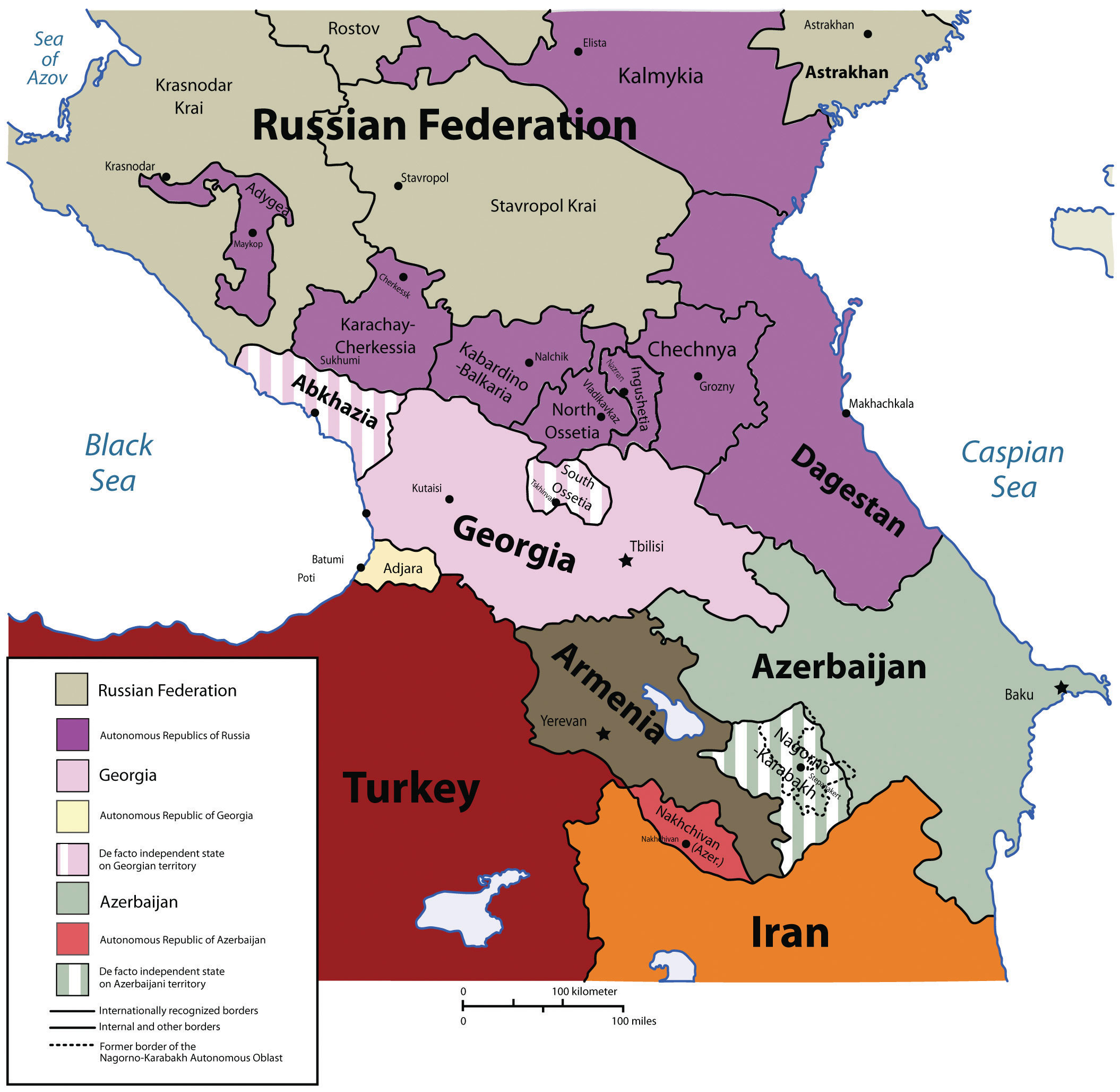
- Caucasus States: Georgia, Armenia, Azerbaijan, a volatile region of ethnic conflict
- Central Asian States: Kazakhstan, Uzbekistan, Turkmenistan, Kyrgyzstan, Tajikistan
The 1990s brought economic collapse, declining life expectancy, and the rise of oligarchs, businessmen who acquired state assets during chaotic privatization. Russia's GDP fell by nearly 50% between 1991 and 1998.
Global Theme: Energy Geopolitics
Russia holds vast oil and natural gas reserves, making energy a key tool of geopolitical influence. Russia ranks among the world's top three producers of both oil and natural gas.
Energy as Power
European dependence on Russian gas gave Moscow significant leverage. Pipelines like Nord Stream connected Russia directly to Western Europe, bypassing transit countries like Ukraine. Energy revenues funded Russian government spending and military modernization.

The Ukraine Conflict
The 2022 Russian invasion of Ukraine marked a dramatic escalation in post-Soviet tensions. Geographic factors include:
- Ukraine's position: A buffer state between Russia and NATO
- Crimea: Annexed by Russia in 2014; home to strategic naval base at Sevastopol
- Donbas: Industrial region with Russian-speaking population
- Energy transit: Pipelines crossing Ukraine to Europe
The war has reshaped global energy markets, intensified NATO expansion, and created Europe's largest refugee crisis since World War II.
Geographic Inquiry
Ukraine's geography places it at the intersection of European and Russian spheres of influence. How might Ukraine's physical geography (landlocked except for small Black Sea access), history of empire, and language communities create competing geographic identities and geopolitical claims?
Data Exploration: Russia's Resource Economy
Russia's economy is heavily dependent on natural resources, particularly oil and natural gas. These visualizations show the composition of Russia's resource wealth and the sectors that drive the national economy.
Interpretation: Notice how energy resources dominate Russia's economy. This concentration creates both wealth and vulnerability, when global energy prices fall, the entire economy suffers. How might Russia diversify its economy to reduce this dependence?
Central Asia: The Post-Soviet Stans
The five Central Asian republics share Soviet heritage, predominantly Muslim populations (though secular by tradition), and the geographic challenge of being landlocked, no access to the open ocean. Since independence in 1991, each has charted its own path.
Country Profiles
Kazakhstan
Population: 19 million | Area: 2.7 million km² (world's 9th largest)
- Vast oil reserves in the Caspian Sea region (Kashagan, Tengiz fields)
- Significant Russian minority (24%) in the north, near the border
- Soviet-era Baikonur Cosmodrome, Russia still launches spacecraft from here
- Moved capital from Almaty to Astana (now Nur-Sultan) to balance population
Uzbekistan
Population: 35 million (Central Asia's most populous) | Area: 447,000 km²
- Historic Silk Road cities: Samarkand, Bukhara, Khiva
- World's 6th largest cotton producer, but irrigation has devastated the Aral Sea
- Significant authoritarian governance; opening up slowly since 2016
Turkmenistan
Population: 6 million | Area: 488,000 km² (80% Karakum Desert)
- World's 4th largest natural gas reserves
- Among the world's most isolated and repressive governments
- Relies almost entirely on gas exports to China
Kyrgyzstan
Population: 7 million | Area: 200,000 km² (94% mountainous)
- Central Asia's most democratic state, though still turbulent
- Economy relies on remittances from workers in Russia and Kazakhstan
- The Tian Shan mountains dominate, average elevation over 9,000 feet
Tajikistan
Population: 10 million | Area: 143,000 km² (93% mountainous)
- Central Asia's poorest country, GDP per capita under $1,000
- Experienced brutal civil war (1992-1997) after independence
- Pamir Mountains include some of the world's highest peaks
- Nearly half of GDP comes from remittances from workers abroad
The Aral Sea Disaster
The Aral Sea catastrophe stands as one of history's worst environmental disasters. In 1960, the Aral Sea covered 68,000 km², the world's fourth-largest lake. Soviet planners diverted its feeder rivers (Amu Darya and Syr Darya) to irrigate cotton fields. By 2014, the lake had shrunk to 10% of its original size. Consequences include:
- Fishing industry collapse, fishing towns now sit 150 km from water
- Toxic dust storms from the exposed seabed, containing pesticide residues
- Dramatic regional climate changes, hotter summers, colder winters
- Public health crisis with elevated rates of cancer and respiratory disease
Geopolitical Competition: The New Great Game
Central Asia sits at the crossroads of competing powers:
- Russia: Former colonial power, maintains military bases, security cooperation
- China: Massive investment through Belt and Road Initiative, purchases energy
- United States: Maintained military bases during Afghanistan war, now minimal presence
- Turkey: Cultural ties to Turkic-speaking populations (all except Tajikistan)
The region's oil, gas, and strategic location between major powers ensure continued international competition.
The Aral Sea Disaster: Engineering an Environmental Catastrophe
The Aral Sea catastrophe stands as one of history's most dramatic examples of how political decisions can reshape physical geography. In 1960, the Aral Sea was the world's fourth-largest lake, covering 68,000 km² and supporting a thriving fishing industry across the Soviet republics of Kazakhstan and Uzbekistan.
The Cause
Soviet central planners diverted the Aral Sea's two feeder rivers, the Amu Darya and Syr Darya, to irrigate cotton fields across Central Asia. Cotton was a strategic export commodity ("white gold"), and the Soviet government prioritized production quotas over environmental consequences. By the 1980s, nearly 90% of the rivers' flow was being diverted before it reached the lake.
The Consequences
- Lake collapse: By 2014, the lake had shrunk to roughly 10% of its original size. The eastern basin dried up entirely in some years.
- Fishing industry destruction: Former fishing towns like Moynaq in Uzbekistan now sit over 150 km from any water. Rusting ships in the desert have become a symbol of the disaster.
- Toxic dust storms: The exposed lakebed releases salt and pesticide residues into the atmosphere, causing respiratory disease across the region.
- Climate change: The loss of the lake's moderating influence has produced hotter summers and colder winters in surrounding areas.
- Public health crisis: Elevated rates of cancer, anemia, and kidney disease have been documented in communities near the former shoreline.
Recovery Efforts
Kazakhstan's Kok-Aral Dam, completed in 2005 with World Bank support, has partially restored the Northern Aral Sea. Water levels have risen, salinity has decreased, and fish populations are returning. However, the much larger Southern Aral Sea in Uzbekistan remains essentially lost. The Aral Sea disaster demonstrates a core geographic principle: human modifications to physical systems often produce cascading, irreversible consequences that extend far beyond the original intervention.
Analysis Questions
- How does the Aral Sea disaster illustrate the tension between economic development and environmental sustainability?
- Why was the Northern Aral Sea partially recoverable while the Southern Aral Sea was not? Consider both geographic scale and political boundaries in your answer.
- Permafrost
- Permanently frozen subsoil occurring in perennially cold climates, covering approximately 65% of Russian territory. Thawing permafrost threatens infrastructure and releases stored methane.
- Taiga
- The vast boreal (coniferous) forest covering much of Siberia, the world's largest land biome, containing roughly 25% of global forests.
- Tundra
- A treeless polar climate zone where the subsoil remains frozen year-round, supporting only mosses, lichens, and low shrubs.
- Continental Climate
- A climate characterized by extreme temperature variations between seasons, typical of interior regions far from moderating ocean influence.
- Russification
- Policies promoting Russian language, culture, and migration into non-Russian areas, practiced under both Tsarist and Soviet regimes.
- SSRs (Soviet Socialist Republics)
- The 15 constituent republics of the Soviet Union, each theoretically representing a major ethnic group. All became independent nations in 1991.
- Command Economy
- An economic system where the government controls production, distribution, and pricing rather than market forces. The Soviet system 1928-1991.
- Five-Year Plans
- Soviet economic planning cycles setting industrial production targets, beginning in 1928 under Stalin. Prioritized heavy industry over consumer goods.
- Oligarchs
- Ultra-wealthy business leaders who acquired vast state assets during 1990s privatization; maintain significant political influence in post-Soviet states.
- Near Abroad
- Russian term for the 14 former Soviet republics that Moscow views as its essential sphere of influence and security buffer.
- Landlocked
- A state with no direct access to the ocean, creating trade dependency on neighbors. All five Central Asian republics are landlocked.
- Resource Curse
- The paradox where countries rich in natural resources often have weaker governance, higher corruption, and less economic diversification.
- Petro-State
- A nation whose economy and government revenue depend heavily on oil and gas exports, making it vulnerable to commodity price swings.
- Glasnost
- Russian for "openness." A policy introduced by Mikhail Gorbachev in the late 1980s that loosened censorship, permitted public debate, and increased government transparency, inadvertently accelerating the collapse of the Soviet Union.
- Perestroika
- Russian for "restructuring." Gorbachev's program of economic reforms intended to modernize the Soviet command economy by introducing limited market mechanisms and decentralizing some economic decision-making.
- Buffer State
- A smaller, neutral country located between two rival or potentially hostile powers. Ukraine and Belarus have historically served as buffer states between Russia and Western Europe.
- Aral Sea
- A formerly vast inland sea on the Kazakhstan-Uzbekistan border that has shrunk to roughly 10% of its original size since the 1960s due to Soviet-era irrigation diversions, representing one of the world's worst environmental disasters.
- Exclave
- A portion of a country geographically separated from the main territory. Kaliningrad is a Russian exclave between Poland and Lithuania.
- Geography shapes governance: Russia's immense size (11 time zones) creates "distance decay", the difficulty of governing and developing distant regions from Moscow.
- Climate limits settlement: Permafrost covers 65% of Russia; extreme continental climate concentrates population in the western third of the country.
- Soviet legacy endures: The USSR's 1991 collapse created 15 new nations, ethnic conflicts, and borders that still generate tension (Ukraine, Nagorno-Karabakh, Transnistria).
- Energy dependence: Russia functions as a "petro-state", oil and gas provide roughly half of government revenue and most exports, creating vulnerability to price swings.
- Demographic crisis: Russia faces population decline from low birth rates, emigration, and reduced life expectancy, threatening long-term economic competitiveness.
- Central Asia's strategic value: The five "-stan" countries sit at the crossroads of Russian, Chinese, and Western interests, with vast energy reserves and growing geopolitical importance.
- Environmental legacy: Soviet central planning created environmental disasters (Aral Sea, nuclear testing sites, industrial pollution) whose effects persist today.
- The "Near Abroad" concept: Russia views former Soviet republics as its security buffer and sphere of influence, a perspective that drives conflicts with Western institutions like NATO and the EU.
- The New Great Game: Central Asia sits at the crossroads of Russian, Chinese, American, and Turkish geopolitical competition. Control over energy pipelines, military bases, and trade corridors ensures this region will remain a focal point of international rivalry for decades to come.
The Ukraine Crisis: Geography, Sovereignty, and Security
Ukraine is a pivotal country at the crossroads of Europe and Russia, a geographic "shatter belt" where great power interests collide. Russia's 2022 invasion of Ukraine triggered the largest land war in Europe since World War II. You are attending an emergency UN Security Council session to address the crisis and propose a path forward.
Role A: Russia
You argue that NATO's eastward expansion threatens your security buffer zone. Ukraine's flat terrain, the same plains that Napoleon and Hitler used to invade Russia, makes it a strategic necessity. You see the Donbas and Crimea as historically Russian territories. You demand Ukraine remain neutral and outside NATO.
Role B: Ukraine
You are a sovereign nation with the right to choose your own alliances. Russia has violated international law by annexing Crimea (2014) and invading your territory. You demand full restoration of your internationally recognized borders and NATO membership as a security guarantee.
Role C: Germany (EU Representative)
You depend on Russian natural gas and have deep economic ties with Russia. You support Ukraine's sovereignty but fear escalation to nuclear conflict. You must balance your security commitments to NATO with your economic vulnerabilities and your role as Europe's largest economy.
Role D: UN Secretary-General
You must propose a ceasefire framework that all parties can accept. You have no military power, only moral authority and diplomatic tools. You must navigate the veto power of Russia on the Security Council while addressing the humanitarian catastrophe unfolding in Ukraine.
The Arctic: Russia's New Frontier
Climate change is rapidly melting Arctic sea ice, opening new shipping lanes and exposing vast reserves of oil, natural gas, and minerals beneath the Arctic seabed. Russia, which controls the longest Arctic coastline of any nation, has aggressively staked its claims in the region by building military bases, deploying icebreakers, and planting a titanium flag on the seabed beneath the North Pole. The Arctic has become one of the most consequential geopolitical frontiers of the 21st century. You are a delegate at an Arctic Council emergency session convened to negotiate the future of this rapidly changing region.
Role A: Russia
You control the Northern Sea Route along your Arctic coast and have invested billions in military infrastructure and icebreaker fleets. You argue that the Lomonosov Ridge is a geological extension of your continental shelf, entitling you to vast undersea resource claims. You view the Arctic as essential to your economic future as traditional oil fields in western Siberia decline. You demand international recognition of your extended continental shelf claims and exclusive control over the Northern Sea Route.
Role B: Norway
You are a fellow Arctic state with extensive offshore energy experience in the North Sea. You advocate for a rules-based approach under the United Nations Convention on the Law of the Sea (UNCLOS). You support sustainable resource development with strict environmental standards and want to ensure that all Arctic nations, including smaller states like Iceland and Denmark (Greenland), have a voice in governance decisions. You are wary of Russia's military buildup but also depend on cooperative fisheries management in the Barents Sea.
Role C: Indigenous Peoples (Inuit Circumpolar Council)
Your communities have inhabited the Arctic for thousands of years and depend on its ecosystems for cultural survival and subsistence. You demand that indigenous peoples have a formal seat at the negotiating table, not merely observer status. You oppose industrial development that threatens caribou migration, marine mammal habitats, and traditional hunting grounds. You argue that any resource extraction must require free, prior, and informed consent from affected indigenous communities.
Role D: International Environmental Organization
You represent a coalition of environmental scientists and conservation groups. You present evidence that Arctic drilling poses catastrophic risks: oil spills in ice-covered waters are nearly impossible to clean up, and methane released from thawing permafrost accelerates global warming. You call for a moratorium on new fossil fuel extraction in the Arctic and propose that the region be designated an international commons, similar to Antarctica, protected by a binding treaty that prioritizes climate science and ecosystem preservation.
Data Exploration: Russia's Energy Dependency
Russia is one of the world's largest exporters of fossil fuels. The chart below shows the percentage of government revenue derived from oil and gas exports, illustrating why Russia is called a "petro-state" and how vulnerable its economy is to global energy price fluctuations.
Interpretation: Notice how Russia's oil revenue share spikes with global oil price booms (2008, 2014, 2022) and crashes when prices fall. How does this geographic resource dependency shape Russia's foreign policy behavior?
Knowledge Check
Test your understanding of the core concepts covered in this chapter. This quiz consists of multiple-choice questions designed to review key terms, regional patterns, and geographic relationships. Select the best answer for each question to receive immediate feedback.
Loading quiz questions...
Discussion and Reflection Prompts
Reflect on Your Learning
- Energy Geopolitics: How do Russia's oil and gas reserves shape its relationships with Europe, Asia, and the rest of the world? What geographic advantages or vulnerabilities does this create?
- Geographic Isolation: Why do Russia's vast distances and harsh climate make development so challenging? How do these physical constraints explain regional inequality?
- Historical Cycles: How does understanding Russia's geography help explain its cyclical patterns of expansion, contraction, and re-expansion throughout history?
Discuss With Your Peers
- How does Russia's geographic position between Europe and Asia shape its political identity and international relations?
- What role should environmental sustainability play in Russia's resource extraction industries?
- How might climate change impact Russia's Arctic regions and global influence?
Curriculum Standards Alignment
This chapter aligns with the following National and State geography standards.