At a Glance
At a Glance
Learning Outcomes
- Describe: The monsoon winds and tectonic collision forming the Himalayas.
- Analyze: The 1947 Partition of British India and its geopolitical legacy (Kashmir).
- Explain: The economic potential of the Demographic Dividend.
- Evaluate: Vulnerability to climate change (glacial melt, sea-level rise in Maldives).
- Apply: Development concepts like Microcredit (Grameen Bank).
Key Terms
Monsoon, Partition, Demographic Dividend, Microcredit, Caste System, Buffer State, Forward Capital, Double Delta, Rain Shadow, Orographic Precipitation, Physiologic Density.
Stop & Check
Reveal Answer
Common Misconception
Myth: "Monsoon" just means heavy rain.
Fact: A monsoon is a seasonal reversal of wind direction. The summer monsoon (wet, onshore winds from the Indian Ocean) brings rain; the winter monsoon (dry, offshore winds from Central Asia) brings drought. It is a climate system, not merely a storm event.
Regional Snapshot: The Indian Subcontinent
South Asia is a textbook example of a "physiographic region," bounded by the world's highest mountains to the north and the Indian Ocean to the south. The subcontinent includes eight principal political units: India, Pakistan, Bangladesh, Nepal, Bhutan, Sri Lanka, the Maldives, and Afghanistan (sometimes grouped with Southwest Asia). The region contains roughly one quarter of all humanity, concentrated primarily in the fertile river plains of the Indus, Ganges, and Brahmaputra. Despite its relatively modest land area (approximately 5.2 million square kilometers, roughly the size of the contiguous United States), South Asia's population density, cultural diversity, and economic dynamism make it one of the most consequential regions in global geography.

Interactive Map: The Subcontinent
Explore the physical barriers of the Himalayas and the dense urban centers of the Ganges Plain. Click on major cities like Delhi, Mumbai, and Dhaka to learn about their explosive growth. Toggle between physical terrain and political boundaries to observe how river systems define the borders and population centers of the region.
Toggle between Physical terrain and Political boundaries. Notice how the river systems define the borders and population centers.
Physical Geography: Mountains and Monsoons
South Asia's physical geography is dominated by the ongoing collision of tectonic plates. Approximately seventy million years ago, the Indian Plate separated from the ancient supercontinent of Gondwana and began its northward journey toward the Eurasian Plate. The resulting collision, which continues today, has produced the highest mountain ranges on Earth and created the distinctive physical framework that defines the subcontinent. From the towering peaks of the Himalayas to the low-lying deltas of Bangladesh, this region encompasses an extraordinary range of physical environments within a comparatively small area.
The Himalayan Wall: Tectonic Origins and Geographic Significance
The Himalayas represent the most dramatic result of continental plate collision anywhere on Earth. The Indian Plate continues to push into the Eurasian Plate at a rate of approximately 40 to 50 millimeters per year, causing the mountains to rise by one to five millimeters annually. This ongoing tectonic activity makes the region seismically volatile; the devastating 2015 Nepal earthquake (magnitude 7.8) killed nearly 9,000 people and demonstrated the persistent hazard that plate tectonics poses to the densely populated foothills.
The Himalayan system stretches roughly 2,400 kilometers in an arc from the Hindu Kush and Karakoram ranges in the northwest to the mountains of Myanmar in the southeast. It contains the world's fourteen highest peaks above 8,000 meters, including Mount Everest (8,849 meters), K2 (8,611 meters), and Kangchenjunga (8,586 meters). These peaks are not merely physical landmarks; they hold profound spiritual significance for millions of people. Mount Kailash, in the western Himalayas, is considered sacred by Hindus, Buddhists, Jains, and followers of Bon, illustrating how physical geography and cultural geography intersect.
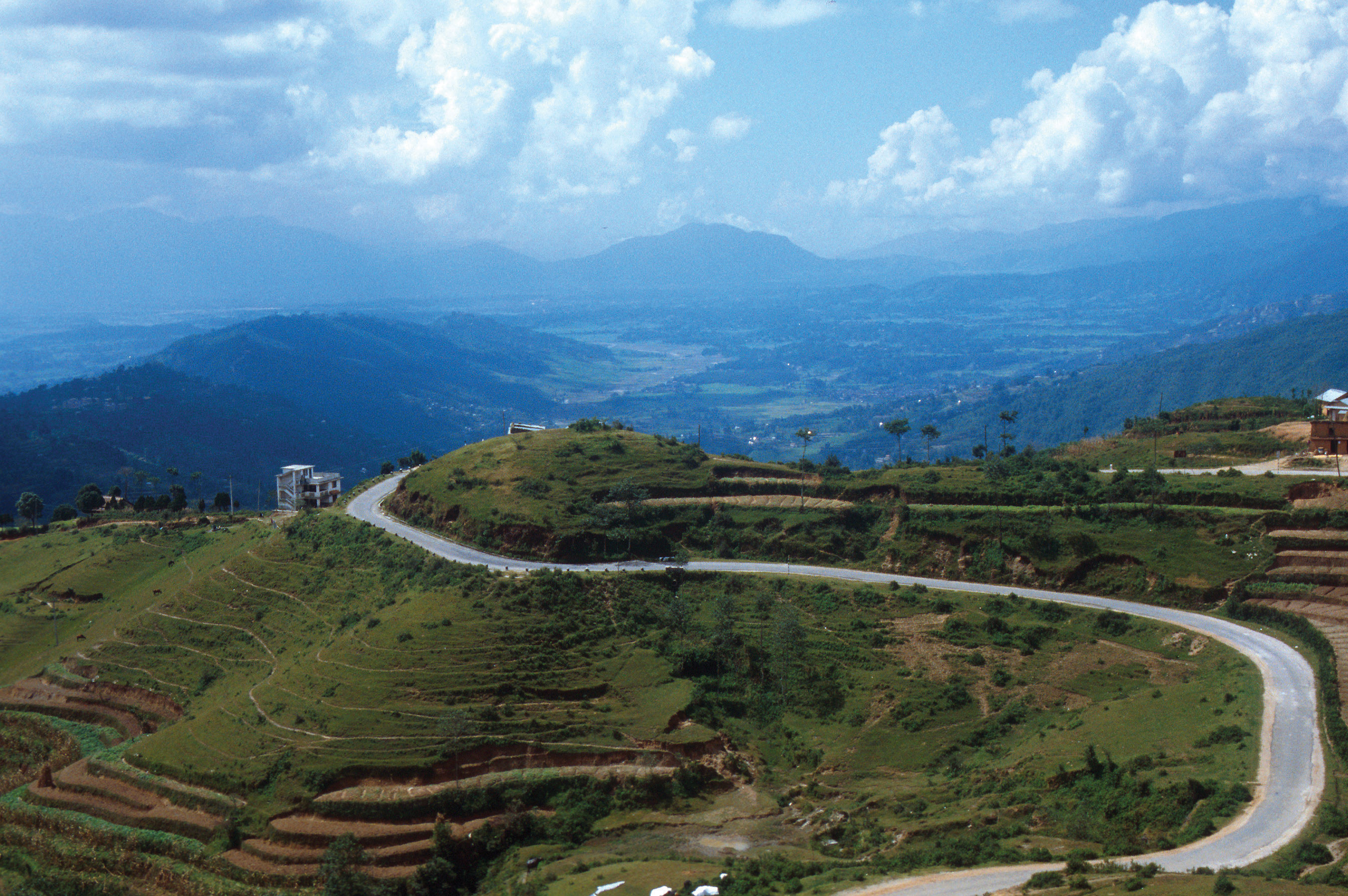
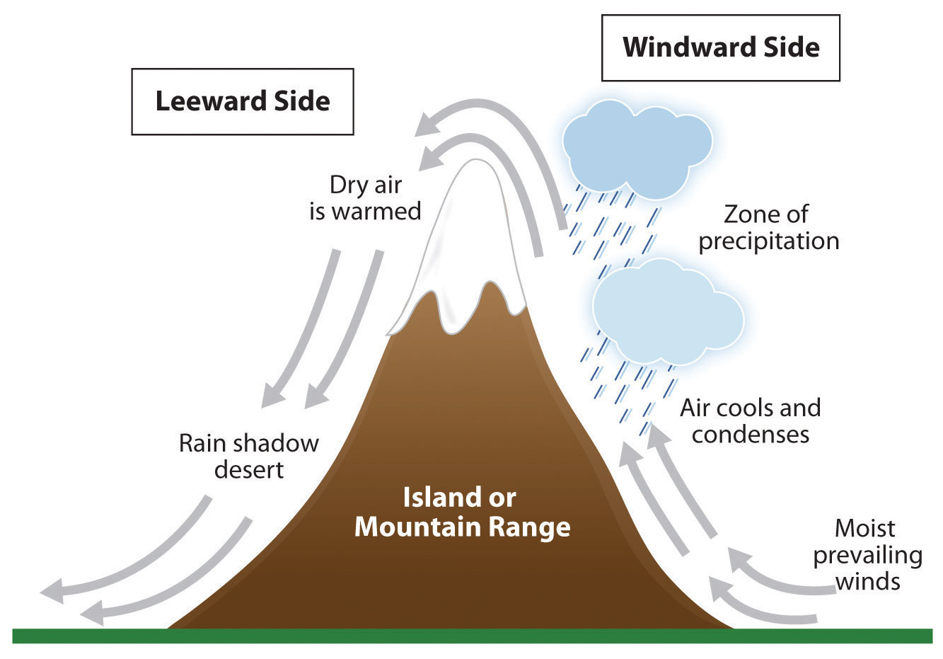
Geopolitically, the Himalayas function as a natural barrier between South Asia and East Asia. Nepal and Bhutan serve as buffer states between the regional powers of India and China, a role made possible by the extreme terrain. The mountains on the border between Pakistan and Afghanistan, including the famous Khyber Pass, have served as invasion corridors for millennia, from Alexander the Great to the Mughal emperors. The rain shadow effect created by the Himalayas means that the northern side (the Tibetan Plateau) receives minimal precipitation, while the southern slopes intercept enormous volumes of monsoon moisture, creating some of the wettest places on Earth. Cherrapunji, in the Indian state of Meghalaya, has recorded annual rainfall exceeding 11,000 millimeters, making it one of the rainiest locations on the planet.
The Indo-Gangetic Plain: Agricultural Heartland
South of the Himalayas lies the Indo-Gangetic Plain, one of the largest and most fertile alluvial plains in the world. Stretching approximately 2,400 kilometers from the Indus Valley in Pakistan through northern India to the Bengal Delta in Bangladesh, this plain was formed by millions of years of sediment deposition from Himalayan rivers. The alluvial soil is remarkably productive, supporting multiple harvests per year and sustaining what is arguably the densest concentration of agricultural population on Earth.
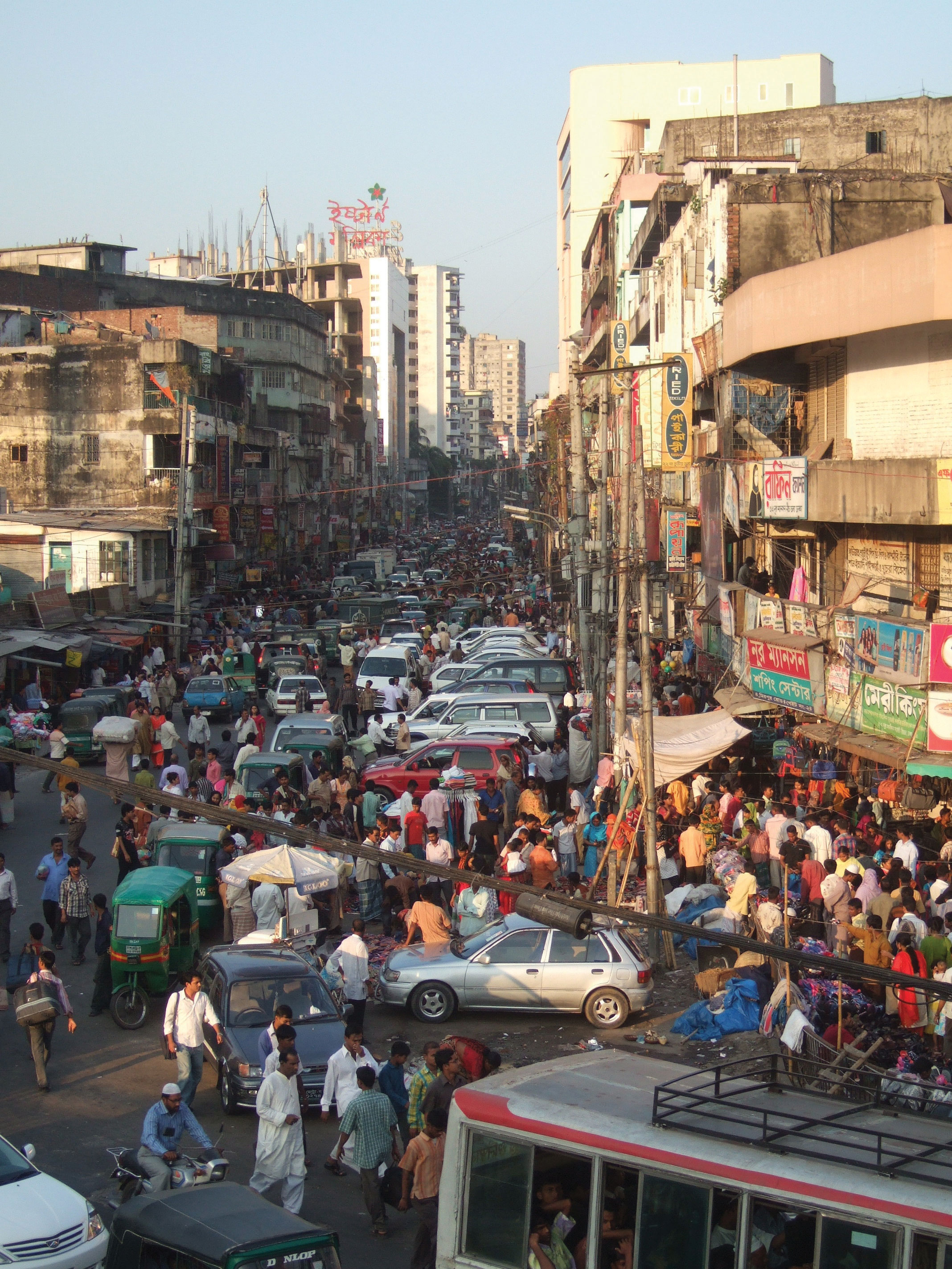
The Indo-Gangetic Plain is home to hundreds of millions of people. The population density in the Ganges basin regularly exceeds 1,000 people per square kilometer, rivaling the most densely populated areas of East Asia. This extraordinary concentration of humanity is directly attributable to the physical geography: flat terrain, deep fertile soils, abundant water from the Ganges and its tributaries, and the reliable arrival of monsoon rains. Major cities such as Delhi, Lucknow, Varanasi, Patna, and Kolkata all sit within this plain, and the corridor between Delhi and Kolkata has historically been considered the political and cultural heartland of the subcontinent.
The agricultural productivity of the plain has also made it strategically important throughout history. Every major empire in South Asian history, from the Mauryan Empire (322 to 185 BCE) through the Mughal Empire (1526 to 1857) to the British Raj, sought to control this fertile corridor. The Green Revolution of the 1960s and 1970s, which introduced high-yield crop varieties and modern irrigation techniques, was most successful in the western portion of the plain (particularly the Punjab region), dramatically increasing wheat and rice production but also creating concerns about groundwater depletion and soil degradation.
The Monsoon System: Life and Destruction
The monsoon is the single most important climate phenomenon in South Asia. It is not merely a rainstorm; it is a seasonal reversal of wind direction driven by differential heating of land and ocean surfaces. Understanding the monsoon is essential for understanding nearly every aspect of South Asian geography, from agriculture and settlement patterns to religious festivals and economic cycles.
During the summer months (June through September), the Asian landmass heats up intensely, with the Thar Desert in western India acting as a thermal engine. The rising hot air creates a low-pressure zone that draws warm, moisture-laden air from the Indian Ocean and the Bay of Bengal. As these moisture-laden winds move inland and encounter the Western Ghats and the Himalayas, the air is forced upward in a process called orographic precipitation. The water vapor condenses and falls as heavy rain, delivering the vast majority of the region's annual rainfall in just four months.
By October, the system reverses. The Asian continent cools rapidly, creating a high-pressure zone that pushes dry, cool air southward. This winter monsoon brings dry conditions across most of South Asia, though parts of southeastern India and Sri Lanka receive rainfall from the retreating monsoon as it picks up moisture from the Bay of Bengal. The agricultural calendar of the entire region is structured around this annual cycle: the kharif (summer) crop season aligns with the wet monsoon, while the rabi (winter) crop season takes advantage of residual soil moisture and irrigation.
The monsoon is both a blessing and a catastrophe. A "good" monsoon year means bountiful harvests, low food prices, and strong economic growth. A "bad" monsoon, either too little rain or too much, can result in drought, famine, devastating floods, and economic contraction. Bangladesh is particularly vulnerable: situated in the low-lying delta where the Ganges and Brahmaputra converge, it experiences catastrophic flooding nearly every year. The country regularly loses five to ten percent of its territory to seasonal inundation, and climate scientists warn that sea-level rise will compound this vulnerability significantly in the coming decades.
The Deccan Plateau and Peninsular India
South of the Indo-Gangetic Plain, the Deccan Plateau occupies most of peninsular India. This is geologically much older than the Himalayas, consisting of ancient Precambrian rock (some formations exceeding 600 million years in age) that formed part of the original Indian Plate. The Deccan is flanked on its western and eastern margins by two mountain ranges known as the Western Ghats and the Eastern Ghats.
The Western Ghats are the more prominent of the two ranges, rising to elevations of 1,000 to 2,600 meters and running parallel to the Arabian Sea coast for approximately 1,600 kilometers. They are recognized as a UNESCO World Heritage Site and one of the world's eight "hottest hotspots" of biological diversity, harboring over 7,400 species of flowering plants, 139 mammal species, and 508 bird species. The Western Ghats also serve a critical hydrological function: they intercept the southwest monsoon, causing heavy rainfall on the windward (western) coast while creating a rain shadow on the leeward (eastern) side of the plateau.
The Eastern Ghats are lower and more fragmented, rarely exceeding 600 meters. Between the two Ghat ranges, the Deccan Plateau itself is a semi-arid tableland with basaltic soils (particularly in the northwestern Deccan, where the Deccan Traps represent one of the largest volcanic provinces on Earth). Agriculture on the plateau is less productive than in the Indo-Gangetic Plain, relying more heavily on irrigation and drought-resistant crops such as millet and sorghum. Major cities on the plateau include Bangalore (Bengaluru), Hyderabad, and Pune, all of which have emerged as important centers of India's technology and service economy.
River Systems and Water Geography
Three great river systems define the hydrology of South Asia, each originating in the Himalayan snowfields and glaciers. These rivers are not merely physical features; they are central to the cultural identity, economic vitality, and geopolitical tensions of the region.
The Ganges (Ganga) is the most sacred river in Hinduism. Rising in the Gangotri Glacier of Uttarakhand, it flows approximately 2,525 kilometers through the heart of northern India before emptying into the Bay of Bengal through the vast Sundarbans delta in Bangladesh. The Ganges basin supports over 400 million people, making it the most densely populated river basin in the world. Despite its sacred status, the river is severely polluted by industrial effluent, untreated sewage, and agricultural runoff. The Indian government has launched several initiatives (including the Namami Gange program) to address pollution, but progress has been slow given the sheer scale of the challenge.
The Indus River, which gave India its very name, originates in Tibet and flows 3,180 kilometers through Pakistan to the Arabian Sea. The Indus Valley was home to one of the world's earliest urban civilizations (the Indus Valley Civilization, circa 3300 to 1300 BCE), and the river remains the lifeline of Pakistan, providing water for irrigating the Punjab ("Land of Five Rivers") and Sindh provinces. The Indus Waters Treaty of 1960, brokered by the World Bank between India and Pakistan, is one of the most enduring transboundary water agreements in history. It allocated the three eastern tributaries (Ravi, Beas, Sutlej) to India and the three western tributaries (Indus, Jhelum, Chenab) to Pakistan. However, climate change, glacial melt, and growing demand are placing increasing stress on this agreement, making water a potential flashpoint in an already volatile relationship.
The Brahmaputra originates in Tibet (where it is called the Yarlung Tsangpo), traverses a dramatic gorge through the eastern Himalayas, and flows through Assam in northeastern India before joining the Ganges in Bangladesh. Together, the Ganges and Brahmaputra form the world's largest double delta, a vast, low-lying floodplain that is extraordinarily fertile but also extremely vulnerable to flooding, cyclones, and sea-level rise. Bangladesh, which sits primarily on this delta, faces perhaps the greatest climate-related existential threat of any major nation.
Geographic Inquiry
Bangladesh lies on the low-lying delta where the Ganges and Brahmaputra rivers meet the sea. How does this specific physical geography make it uniquely vulnerable to both monsoon flooding from the north and cyclonic storm surges from the south? Consider how climate change may intensify both threats simultaneously.

Important Person
Economist & Nobel Laureate
Amartya Sen (born 1933) is a Nobel Prize-winning economist and philosopher from Bengal whose work fundamentally redefined development geography. His research on the Bengal Famine of 1943 demonstrated that famines are caused not by a lack of food, but by "entitlement failure," the inability of people to access food through legal and economic channels. His Capabilities Approach shifted the focus of global development from GDP measurement to human well-being, directly inspiring the creation of the Human Development Index (HDI) used by the United Nations. Sen's work reminds geographers that development is ultimately about expanding the real freedoms that people enjoy, including access to education, healthcare, and political participation.
Explore Sen's impact on development →Human Geography: Peoples, Politics, and Development
South Asia's human geography is shaped by extraordinary diversity: religious, linguistic, ethnic, and economic. The region is the birthplace of four major world religions, the site of one of history's most traumatic political partitions, and now the stage for a demographic transformation that could reshape the global economy. Understanding these human dimensions is essential for appreciating both the opportunities and the challenges that face the subcontinent in the twenty-first century.
Cradle of Religions: Sacred Geographies
South Asia is the birthplace of Hinduism, Buddhism, Jainism, and Sikhism, four of the world's major religious traditions. Each of these faiths has created a distinctive sacred geography that shapes patterns of pilgrimage, settlement, land use, and political identity across the region.
Hinduism, practiced by approximately 80 percent of India's population, is the oldest of these traditions, with roots extending back more than 4,000 years to the Vedic period. Hindu sacred geography is inscribed across the landscape through temple complexes, pilgrimage routes (tirthas), and sacred rivers, above all the Ganges. The city of Varanasi, situated on the banks of the Ganges, is one of the oldest continuously inhabited cities in the world and the most sacred site in Hinduism. Millions of pilgrims travel there each year to bathe in the river and cremate their dead along its ghats (stepped riverbanks).
Buddhism emerged in the sixth century BCE when Siddhartha Gautama attained enlightenment at Bodh Gaya in present-day Bihar, India. Although Buddhism subsequently spread across East and Southeast Asia, its geographic footprint in South Asia has diminished to minority status in most countries, with the notable exceptions of Sri Lanka (where approximately 70 percent of the population is Buddhist) and Bhutan (the world's only officially Buddhist state). Jainism, which emphasizes non-violence (ahimsa) to an extraordinary degree, has a small but economically influential community concentrated in western India. Sikhism, founded in the Punjab region in the fifteenth century, numbers approximately 25 million adherents and played a pivotal role in the Partition of 1947, when the Punjab was divided between India and Pakistan.
Islam arrived in South Asia through Arab traders along the western coast as early as the seventh century and later through Central Asian invasions that established the Delhi Sultanate (1206 to 1526) and the Mughal Empire (1526 to 1857). Today, South Asia contains more Muslims than the entire Middle East: India alone has approximately 200 million Muslims, making it one of the largest Muslim populations of any country. Pakistan and Bangladesh are both majority-Muslim nations. This religious diversity is a source of both cultural richness and political tension, as the 1947 Partition demonstrated with devastating clarity.
British Colonial Legacy and the Partition of 1947
British colonial rule in South Asia lasted from the formal establishment of the British Raj in 1858 to independence in 1947. The British East India Company had operated in the region since 1600, initially as a trading enterprise, but it gradually expanded its territorial control through a combination of military force, diplomatic manipulation, and exploitation of local rivalries. By the mid-nineteenth century, the Company effectively governed most of the subcontinent.
Colonialism left enduring geographic imprints on South Asia. The British developed the major port cities of Bombay (Mumbai), Calcutta (Kolkata), and Madras (Chennai) as access points for extracting raw materials and exporting them to Britain. They constructed one of the world's largest railroad networks, but designed it primarily to connect hinterland resources with ports rather than to integrate the internal economy. English was imposed as the language of administration, creating a linguistic hierarchy that persists today. The British also introduced Western-style education, legal systems, and bureaucratic institutions, many of which survived independence.
The most consequential geographic event of the colonial era was the Partition of British India in 1947, which created the independent nations of India and Pakistan. The partition was drawn along religious lines by a British lawyer, Sir Cyril Radcliffe, who had never visited the subcontinent. West Pakistan was carved from the Muslim-majority northwest, and East Pakistan was carved from the Muslim-majority east (Bengal). The borders cut through communities, agricultural lands, and irrigation systems. The result was catastrophic: an estimated 10 to 15 million people were displaced in one of the largest mass migrations in human history, and between one and two million people died in the communal violence that accompanied the upheaval. The Sikh community, concentrated in the Punjab region that was split between India and Pakistan, suffered disproportionately.
The geographic consequences of Partition continue to shape the region. East Pakistan, separated from West Pakistan by over 1,600 kilometers of Indian territory and sharing no ethnic or linguistic ties with its western counterpart, fought a war of independence in 1971 and became Bangladesh. The disputed territory of Kashmir, claimed by both India and Pakistan (and partly by China), remains one of the most dangerous flashpoints in global geopolitics, a subject explored in detail in this chapter's Regional Decisions exercise.
The Demographic Dividend: Population as Opportunity
South Asia is currently experiencing a demographic dividend, a period in which the working-age population (roughly 15 to 64 years) is significantly larger than the dependent population (children and the elderly). This demographic window offers an enormous opportunity for economic growth, provided that sufficient jobs, education, and infrastructure are created to absorb the young workforce.
India surpassed China as the world's most populous country in 2023, reaching approximately 1.43 billion people. Unlike China, which faces rapid aging due to decades of the one-child policy, India's population is remarkably young: the median age is approximately 28 years, compared to 38 in China and 44 in Japan. This youth bulge could fuel decades of economic expansion, as occurred in East Asian "tiger economies" during their own demographic windows in the 1970s and 1980s.
However, the demographic dividend is not automatic. It requires investment in education, healthcare, and job creation. South Asia faces significant challenges in all three areas. Literacy rates, while improving, remain uneven (particularly for women in rural areas). Healthcare infrastructure is strained, as the COVID-19 pandemic dramatically illustrated. And the economy must generate millions of new jobs each year simply to keep pace with population growth. If these conditions are not met, the demographic dividend risks becoming a "demographic burden," with large numbers of unemployed young people potentially fueling social instability.
Urbanization is accelerating rapidly across the region. India's urban population is projected to reach 600 million by 2030, creating megacities that strain water, sanitation, housing, and transportation systems. Mumbai, Delhi, Dhaka, and Karachi are among the largest and fastest-growing metropolitan areas in the world. Rural-to-urban migration is driven by both push factors (limited agricultural land, climate vulnerability) and pull factors (economic opportunity, education, social mobility).
The Caste System and Social Geography
The caste system is one of the most distinctive and consequential social institutions in South Asia. Rooted in Hindu religious texts, the traditional caste system (varna) divided society into four hierarchical categories: Brahmins (priests and scholars), Kshatriyas (warriors and rulers), Vaishyas (merchants and farmers), and Shudras (laborers and servants). Below these four categories were communities historically classified as "untouchables" (Dalits), who were assigned the most stigmatized occupations and subjected to severe social discrimination.
The Indian Constitution of 1950, drafted under the leadership of Dr. B.R. Ambedkar (himself a Dalit), formally abolished untouchability and prohibited caste-based discrimination. Affirmative action policies (known as "reservations") set aside seats in government, educational institutions, and public employment for Scheduled Castes and Scheduled Tribes. These policies have produced measurable improvements in educational attainment and political representation for historically marginalized communities.
Nevertheless, caste continues to shape spatial and social patterns across South Asia. In rural areas, residential segregation by caste remains common; Dalit communities often occupy separate quarters on the outskirts of villages, with limited access to wells, temples, and public facilities. Landholding patterns closely follow caste lines, with upper-caste families owning disproportionate shares of agricultural land. In urban areas, caste distinctions are less visible but still operative, influencing marriage patterns, professional networks, and political affiliations. Geographers have documented how caste intersects with other axes of inequality, including gender, religion, and regional identity, to produce complex patterns of social stratification that vary considerably across the subcontinent.
Economic Development and the IT Revolution
South Asia's economic transformation over the past three decades has been remarkable, though highly uneven. India's economy, once characterized by state-led central planning (the so-called "License Raj"), began liberalizing in 1991 under the reforms introduced by Finance Minister Manmohan Singh. The removal of trade barriers, reduction of government control over private enterprise, and opening of foreign investment channels triggered sustained economic growth that has averaged roughly six to seven percent annually.
The most visible symbol of this transformation is the information technology (IT) revolution. Cities like Bangalore (Bengaluru), Hyderabad, Pune, and Chennai have emerged as global hubs for software development, business process outsourcing (BPO), and technology services. India's IT sector generates over $200 billion in annual revenue and employs millions of skilled workers. The sector's success is built on several geographic advantages: a large English-speaking workforce (a legacy of British colonialism), a favorable time zone difference with Western clients (enabling round-the-clock operations), relatively low labor costs, and a strong tradition of technical education, particularly through the Indian Institutes of Technology (IITs).
However, the benefits of economic growth have been distributed unevenly. Western India (anchored by Mumbai, Pune, and Ahmedabad) has generally outpaced eastern India (where Kolkata's heavy industries have declined into rustbelt status). Southern India has thrived in the technology sector, while the northern "Hindi Belt" states of Bihar, Uttar Pradesh, and Madhya Pradesh remain among the poorest. Pakistan and Bangladesh have also experienced economic growth, particularly in textiles and garment manufacturing (Bangladesh is the world's second-largest garment exporter after China), but both countries face challenges related to political instability, infrastructure deficits, and vulnerability to climate change.
Microcredit has emerged as an important development tool in South Asia. The Grameen Bank, founded by Muhammad Yunus in Bangladesh in 1983, pioneered the concept of providing small loans to impoverished individuals (particularly women) who lacked access to traditional banking. The model has been replicated across the developing world and earned Yunus the Nobel Peace Prize in 2006. While microcredit has demonstrably improved livelihoods for millions of borrowers, scholars continue to debate its effectiveness as a long-term poverty reduction strategy.
Data Exploration: South Asia's Population Giants
South Asia is home to nearly 2 billion people, about 25% of humanity, in a region roughly the size of the United States. The chart below compares population size and population density across South Asian nations. Consider how the monsoon climate, river systems, and agricultural potential have shaped where people concentrate.
Interpretation: Bangladesh has one of the world's highest population densities despite being a small, low-lying delta nation. The Maldives, though tiny in total population, has an extraordinarily high population density when measured against its minimal land area. How do the physical geography of the Ganges-Brahmaputra delta and the monsoon climate explain both why so many people live in Bangladesh and why they face such extreme vulnerability to flooding and sea-level rise?
The Maldives: Frontline of Climate Change
The Maldives is an archipelago of approximately 1,200 coral islands grouped into 26 atolls, with an average elevation of just 1.5 meters above sea level. No point in the country exceeds 2.4 meters in elevation, making it the world's lowest-lying nation. The Maldives faces an existential threat from rising sea levels driven by global climate change. The Intergovernmental Panel on Climate Change (IPCC) projects that even moderate warming scenarios could render much of the country uninhabitable by the end of this century.
The Maldivian government has responded to this threat with a combination of diplomatic activism and practical adaptation. Former President Mohamed Nasheed famously held an underwater cabinet meeting in 2009 to draw global attention to the climate crisis. The government has invested in artificial island construction (Hulhumale) and sea walls, and has explored the possibility of purchasing land abroad as a potential refuge for climate migrants. The Maldives has been a leading voice in international climate negotiations, arguing that wealthy nations bear disproportionate responsibility for emissions and should therefore provide financial support for adaptation in vulnerable small island developing states (SIDS).
Questions to Consider:
- Is the Maldives' situation an example of "environmental determinism," or does it demonstrate the complex interaction between human choices and physical geography?
- How does a nation plan for its own potential physical disappearance? What are the legal, ethical, and geographic implications of climate-induced statelessness?
- How does the Maldives' dependence on tourism (which generates the carbon emissions that threaten the islands) illustrate the paradoxes of globalization and sustainability?
- Buffer State
- A small, neutral country situated between two larger, potentially hostile powers. Nepal and Bhutan serve as buffer states between India and China, their independence maintained partly by the extreme terrain of the Himalayas.
- Business Process Outsourcing (BPO)
- The relocation of business tasks (such as customer service, data processing, and software development) to another country where labor costs are lower. India is the world's leading destination for BPO activity, particularly from the United States and Europe.
- Caste System
- A hereditary system of social stratification rooted in Hindu religious texts that traditionally divided society into hierarchical groups (varnas) with assigned occupations. Although constitutionally abolished, caste continues to influence social relations, land ownership, and political identity.
- Demographic Dividend
- A period of economic growth potential that occurs when the working-age population is significantly larger than the dependent population (children and elderly). South Asia is currently in this demographic window.
- Double Delta
- A delta formed by the convergence of two or more major river systems. The Ganges-Brahmaputra delta in Bangladesh is the world's largest example, created where these two river systems merge before emptying into the Bay of Bengal.
- Forward Capital
- A capital city deliberately placed in a region of a country that the government wishes to develop or integrate. Islamabad (Pakistan) was built as a forward capital in 1960 to shift the political center away from Karachi and toward the strategically sensitive northern frontier.
- Indus Waters Treaty
- A water-sharing agreement signed in 1960 between India and Pakistan, brokered by the World Bank. It allocated the eastern rivers (Ravi, Beas, Sutlej) to India and the western rivers (Indus, Jhelum, Chenab) to Pakistan.
- Microcredit
- The practice of providing small loans to impoverished individuals who lack access to traditional banking. Pioneered by Muhammad Yunus and the Grameen Bank in Bangladesh, microcredit aims to enable self-employment and economic self-sufficiency.
- Monsoon
- A seasonal reversal of wind direction caused by differential heating of land and ocean surfaces. In South Asia, the summer (wet) monsoon brings moisture from the Indian Ocean, while the winter (dry) monsoon carries cool air from Central Asia.
- Orographic Precipitation
- Rainfall produced when moist air is forced to rise over a topographic barrier such as a mountain range. The Western Ghats and the Himalayas both trigger orographic precipitation, creating extreme rainfall on windward slopes and rain shadow conditions on leeward sides.
- Partition
- The 1947 division of British India into two independent nations, India and Pakistan, along broadly religious lines. The process triggered one of the largest mass migrations in history and caused between one and two million deaths.
- Physiologic Density
- The number of people per unit area of arable (farmable) land, as opposed to total land area. This measure provides a more accurate picture of population pressure on agricultural resources. Bangladesh has one of the highest physiologic densities in the world.
- Rain Shadow
- A dry area on the leeward (downwind) side of a mountain range, caused by the mountains intercepting moisture-laden air and forcing precipitation on the windward side. The Tibetan Plateau lies in the rain shadow of the Himalayas.
- SAARC
- The South Asian Association for Regional Cooperation, established in 1985 to promote economic and regional integration among eight member states: Afghanistan, Bangladesh, Bhutan, India, the Maldives, Nepal, Pakistan, and Sri Lanka.
- Tectonic Collision: The ongoing collision of the Indian and Eurasian plates created the Himalayas, the world's highest mountain range, which serves as a climate barrier, a political boundary, and a spiritual landscape for billions of people.
- The Monsoon Lifeline: The seasonal reversal of winds drives the monsoon, which delivers the vast majority of South Asia's rainfall. Agricultural productivity, economic growth, and cultural rhythms all depend on the timing and intensity of the monsoon.
- River Systems as Lifelines: The Ganges, Indus, and Brahmaputra river systems support hundreds of millions of people, but also create vulnerability to flooding, water conflict, and climate change through glacial melt.
- Religious Diversity and Sacred Geography: South Asia is the birthplace of Hinduism, Buddhism, Jainism, and Sikhism, while also containing one of the world's largest Muslim populations. Religious identity has profoundly shaped political boundaries and settlement patterns.
- The Partition Legacy: The 1947 division of British India along religious lines remains one of the most consequential geopolitical events of the twentieth century, creating enduring conflicts (particularly over Kashmir) and shaping national identities.
- The Demographic Dividend: South Asia's young population offers enormous economic potential, but realizing this dividend requires massive investment in education, healthcare, and job creation.
- Economic Transformation: India's IT revolution and economic liberalization have produced dramatic growth, but the benefits remain unevenly distributed across regions, classes, and genders.
- Climate Vulnerability: The Maldives, Bangladesh, and Himalayan glacial systems face acute threats from climate change, making South Asia one of the regions most exposed to environmental disruption.
- Caste and Social Stratification: Despite constitutional protections, the caste system continues to shape social geography, land ownership patterns, and access to opportunity across much of the region.
The Kashmir Crisis: Diplomacy at the Himalayas
Kashmir is one of the world's most dangerous flashpoints, a mountainous region claimed by both India and Pakistan (and partly by China), where three nuclear-armed nations share contested borders. A recent military skirmish has escalated tensions. You are part of an emergency diplomatic team tasked with de-escalation.
Role A: India
You consider Kashmir an integral part of India, enshrined in your constitution. You have the world's largest army and a growing economy. You see Pakistani support for militants as the core problem and demand it stop before any talks can begin.
Role B: Pakistan
You argue that the Muslim-majority population of Kashmir should have the right to self-determination, as promised in a 1948 UN resolution. You see India's military presence as an occupation and demand a plebiscite under international supervision.
Role C: Kashmiri Civil Society
Your people have lived under military conflict for decades. You want peace, economic development, and autonomy, but you are divided between those who want independence, those who prefer India, and those who prefer Pakistan.
Role D: UN Security Council
You are deeply concerned about nuclear escalation. You must propose a framework for dialogue that all parties can accept, knowing that both India and Pakistan possess nuclear weapons and that China is watching closely from the Aksai Chin plateau.
Knowledge Check
Test your understanding of the core concepts covered in this chapter. This quiz consists of multiple-choice questions designed to review key terms, regional patterns, and geographic relationships. Select the best answer for each question to receive immediate feedback.
Loading quiz questions...
Discussion and Reflection Prompts
Reflect on Your Learning
- The Monsoon's Double Edge: How can the same geographic phenomenon (the monsoon) be both a blessing and a curse for South Asian societies? Give specific examples from agriculture and disaster risk.
- Partition's Legacy: The 1947 Partition of British India was one of the largest forced migrations in history. How do the borders drawn at that time continue to shape conflict and identity in South Asia today?
- Demographic Dividend or Burden? South Asia has the world's largest youth population. Under what conditions does this become an economic advantage, and when does it become a source of instability?
Discuss With Your Peers
- India and Bangladesh are both downstream nations on rivers that originate in the Himalayas. How does climate change (glacial melting) threaten their water security, and what does this mean for regional cooperation?
- The caste system has been officially illegal in India since 1950, yet it persists in social practice. How do geographic factors (rural isolation, land ownership patterns) help explain why social hierarchies are so difficult to dismantle?
- Sri Lanka, despite being a small island, has achieved much higher human development indicators than its larger neighbors. What geographic and historical factors might explain this divergence?
Curriculum Standards Alignment
This chapter aligns with the following National and State geography standards.