At a Glance
At a Glance
Learning Outcomes
- Describe: How aridity and exotic streams shape settlement patterns across the region.
- Understand: The region as a global Cultural Hearth for monotheism (Judaism, Christianity, Islam).
- Analyze: The geopolitical power of oil reserves and OPEC in shaping international relations.
- Evaluate: Solutions to water scarcity (desalination, dams, qanats) and the conflicts they generate.
- Apply: Geographic concepts to strategic chokepoints such as the Suez Canal and the Strait of Hormuz.
Key Terms
Cultural Hearth, Exotic Stream, Desalination, OPEC, Chokepoint, Fertile Crescent, Monotheism, Arab Spring, Maghreb, Rentier State, Sharia, Sunni, Shia, Sykes-Picot Agreement.
Stop & Check
Reveal Answer
Common Misconception
Myth: "Arab," "Muslim," and "Middle Eastern" all mean the same thing.
Fact: Arab is a linguistic and cultural identity. Muslim is a religious identity. The region includes many non-Arab groups like Persians (Iran), Turks (Turkey), Kurds, and Jews (Israel). Indonesia, which is not in this region at all, has the world's largest Muslim population.
Regional Snapshot: The MENA Realm
The region of North Africa and Southwest Asia (often abbreviated as MENA, for Middle East and North Africa) is a world of stark contrasts. It is the cradle of agriculture and three major monotheistic religions, yet it also hosts some of the most hyper-modern cities on the planet. Geography here is defined by the absolute necessity of water management, the geopolitical significance of oil, and the enduring legacy of cultural hearths that gave birth to writing, urbanization, and organized religion. Despite covering portions of three continents (Africa, Asia, and a sliver of Europe at the Bosporus), the region shares three dominant traits: arid climates, the prevalence of Islam, and the strategic importance of petroleum resources.
Interactive Map: The Crossroads of Three Continents
Explore the strategic chokepoints of the Bosporus, the Suez Canal, and the Strait of Hormuz. Click on historical nodes like Cairo and Jerusalem to understand their enduring spatial significance. Notice how population concentrations cluster along coastlines and river valleys, while vast interior deserts remain largely uninhabited.
Toggle between Physical terrain and Political boundaries. Notice the "Exotic Streams" like the Nile and Euphrates that bring life to the desert.
Physical Geography: Aridity and Adaptation
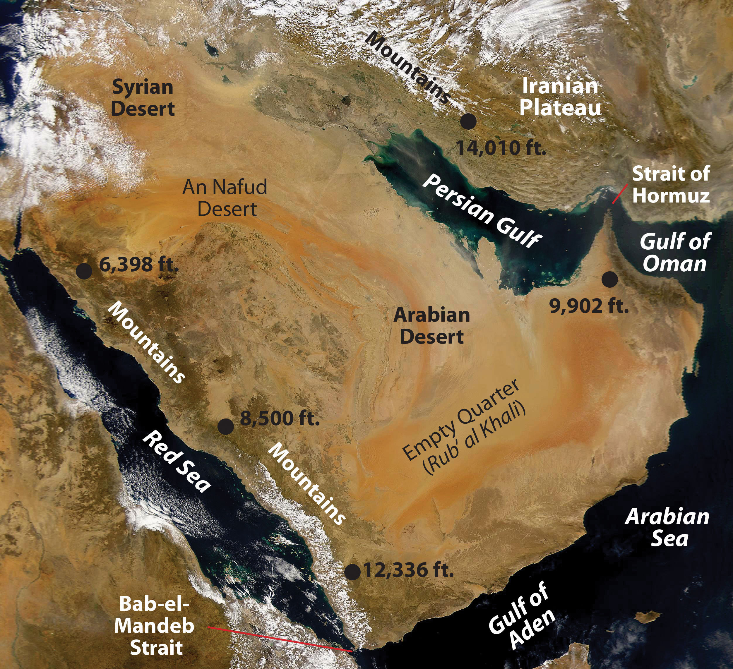
Aridity is the defining physical characteristic of this region. The Sahara Desert, the largest hot desert in the world, and the Arabian Desert, which includes the vast Rub' al-Khali (Empty Quarter), together dictate the fundamental patterns of human settlement, forcing populations to cluster near water sources. Understanding why this region is so dry, where water can be found, and how people have adapted to its scarcity is essential to understanding every other geographic pattern in the MENA realm.

Aridity and Water: The Defining Challenge
The dominant climate across this region is the arid type B climate, which means that potential evaporation exceeds precipitation in most areas. The Sahara Desert stretches across the entire width of North Africa, covering approximately 9.2 million square kilometers and making it comparable in size to the entire United States. To its east, the Libyan Desert and the Nubian Desert extend into Egypt and Sudan. Across the Red Sea, the Arabian Desert dominates the peninsula, with the Rub' al-Khali (Empty Quarter) comprising roughly one quarter of Saudi Arabia. Summer temperatures in these deserts regularly exceed 50 degrees Celsius (120 degrees Fahrenheit), and some areas receive fewer than 25 millimeters of rainfall annually.
This extreme aridity means that water, not oil, is the most strategically important resource in the daily lives of most people. The World Resources Institute classifies the MENA region as the most water-stressed on Earth, with twelve of the world's seventeen most water-scarce countries located here. Populations have developed diverse strategies to cope with this scarcity: the ancient Persians engineered qanats, underground aqueduct systems that channel mountain snowmelt to lowland settlements through gravity-fed tunnels, some of which have operated continuously for over 2,700 years. Modern nations like Saudi Arabia and the United Arab Emirates invest billions of dollars annually in desalination plants that convert seawater into fresh water, though this process is energy-intensive and produces hypersaline brine that damages marine ecosystems when discharged back into coastal waters. Israel has pioneered drip irrigation and wastewater recycling (a technique called fertigation), becoming a global leader in agricultural water efficiency.
Exotic Streams: Rivers of Life
The most important geographic features in this region are its rivers, specifically the rivers that geographers classify as exotic streams. An exotic stream is a river that originates in a humid highland region and flows through an arid zone, losing volume as it travels rather than gaining tributaries. These rivers are the lifelines of the MENA realm, and the civilizations they support are entirely dependent on water sources that lie outside their political control.
The Nile River, the longest river in Africa at approximately 6,650 kilometers, is the most dramatic example. Its headwaters lie in the Ethiopian Highlands and the Great Lakes region of Central Africa, yet its most famous beneficiary is Egypt, which lies at its terminus. The ancient Greek historian Herodotus called Egypt "the gift of the Nile," and this description remains accurate: approximately 95 percent of Egypt's population of over 100 million people lives within a few kilometers of the river or its delta. For thousands of years, the annual flooding of the Nile deposited nutrient-rich silt across the floodplain, enabling intensive agriculture. The construction of the Aswan High Dam in the 1960s and 1970s controlled this flooding but introduced new problems, including salinization of soils and the trapping of fertile silt behind the dam.
The Tigris and Euphrates Rivers form the other great river system of the region. Both rivers originate in the mountains of eastern Turkey and flow southeastward through Syria and Iraq before converging at the Shatt al-Arab waterway, which empties into the Persian Gulf. The land between these rivers, known as Mesopotamia (Greek for "land between rivers"), was the setting for some of humanity's earliest civilizations. Today, all three riparian nations (Turkey, Syria, and Iraq) compete for water from these rivers, and Turkey's construction of massive dams, including the Ataturk Dam on the Euphrates, has significantly reduced downstream flows, generating persistent diplomatic tensions.
The Jordan River, though modest in size compared to the Nile or Euphrates, carries outsized geopolitical significance. Flowing from the mountains of Lebanon through the Sea of Galilee to the Dead Sea, it forms part of the border between Israel, Jordan, and the Palestinian Territories. Competition for Jordan River water has been a contributing factor in multiple Arab-Israeli conflicts, and the Dead Sea, which receives the Jordan's terminus flow, has been shrinking rapidly as upstream diversions reduce inflow.
Climate Zones and Landscapes
Although aridity dominates the region, several distinct climate zones create important geographic variation. The Mediterranean climate (type Cs) is found along the coastal areas of Morocco, Algeria, Tunisia, Libya, Egypt's northern coast, Israel, Lebanon, Syria, and Turkey. This climate features mild, wet winters and hot, dry summers, and it supports the cultivation of olives, grapes, citrus fruits, and wheat. The Mediterranean coastal zone has historically attracted the densest populations and largest port cities, including Algiers, Tunis, Beirut, and Istanbul.
The region's mountain systems create important climatic variation. The Atlas Mountains of Morocco, Algeria, and Tunisia rise to over 4,000 meters and intercept moisture-bearing winds from the Atlantic Ocean, creating a rain shadow effect that contributes to the Sahara's aridity on their leeward side. The Zagros Mountains of Iran and Iraq and the Elburz Mountains of northern Iran similarly trap precipitation and channel snowmelt into river systems that sustain downstream agriculture. In Yemen, mountains exceeding 3,600 meters receive up to 750 millimeters of rainfall annually, supporting a terraced agricultural system that dates back millennia.
Steppe climates (type BS) form transitional zones between the Mediterranean coast and the true desert interior. These semi-arid grasslands support pastoralism and limited dryland farming, and they have historically been the domain of nomadic and semi-nomadic peoples such as the Bedouin of Arabia and the Amazigh (Berber) communities of North Africa.
Strategic Waterways and Chokepoints
The MENA region's location at the junction of three continents gives it extraordinary strategic importance, particularly through its control of maritime chokepoints, narrow passages through which international shipping must pass. The Suez Canal, completed in 1869 under the direction of French engineer Ferdinand de Lesseps, connects the Mediterranean Sea to the Red Sea, eliminating the need for ships to circumnavigate the entire African continent. Approximately 12 to 15 percent of global trade passes through the Suez Canal, including a significant share of European oil imports. Egypt's control of this waterway has been a source of geopolitical tension, most notably during the 1956 Suez Crisis.
The Strait of Hormuz, located between Oman and Iran, is the narrow passage connecting the Persian Gulf to the Gulf of Oman and the broader Indian Ocean. Roughly 20 percent of the world's petroleum supply passes through this strait daily, making it arguably the most strategically important waterway on Earth. Iran's proximity to the strait gives it significant leverage in international politics, as any disruption of tanker traffic would send global oil prices soaring.
The Bab el-Mandeb Strait, connecting the Red Sea to the Gulf of Aden between Yemen and Djibouti, controls access to the Suez Canal from the Indian Ocean. Instability in Yemen and piracy off the coast of Somalia have periodically threatened shipping through this passage. Finally, the Bosporus Strait and the Dardanelles in Turkey connect the Black Sea to the Mediterranean, controlling Russia's access to warm-water ports and giving Turkey significant strategic influence in European and Asian affairs.
Oil and Natural Resources
The region's petroleum reserves are a consequence of its ancient geological history. Hundreds of millions of years ago, the area that is now the Persian Gulf was a shallow sea teeming with marine organisms. As these organisms died and were buried under layers of sediment, heat and pressure gradually transformed their organic material into hydrocarbons. The geological structures of the Arabian Peninsula, with its gently folding anticlines and impermeable cap rocks, created ideal traps for the accumulation of oil and natural gas. Saudi Arabia alone possesses approximately 267 billion barrels of proven oil reserves, the second largest in the world after Venezuela. Other major reserve holders include Iraq, Kuwait, the UAE, and Iran.
The discovery and exploitation of oil fundamentally transformed the region beginning in the early twentieth century. The Anglo-Persian Oil Company (later British Petroleum, or BP) struck oil in Iran in 1908, and major discoveries in Saudi Arabia, Kuwait, and other Gulf states followed in the 1930s and 1940s. The formation of the Organization of the Petroleum Exporting Countries (OPEC) in 1960 by Saudi Arabia, Iran, Iraq, Kuwait, and Venezuela gave producing nations greater control over pricing and production levels. OPEC's 1973 oil embargo, imposed in response to Western support for Israel during the Yom Kippur War, demonstrated the enormous geopolitical leverage that oil-producing nations could wield. Beyond petroleum, the region also possesses significant reserves of natural gas (Qatar holds the world's third-largest reserves), phosphates (Morocco), and minerals in the mountainous zones.
Geographic Inquiry
Nations like the UAE and Saudi Arabia are investing billions in desalination technology. While this provides fresh water, the process requires enormous energy inputs and produces high-salinity brine that is discharged into coastal waters. How does this environmental trade-off illustrate the interconnection between water scarcity, energy resources, and marine geography in the Persian Gulf?
Important Person
Medieval Explorer & Geographer (1304-1369)
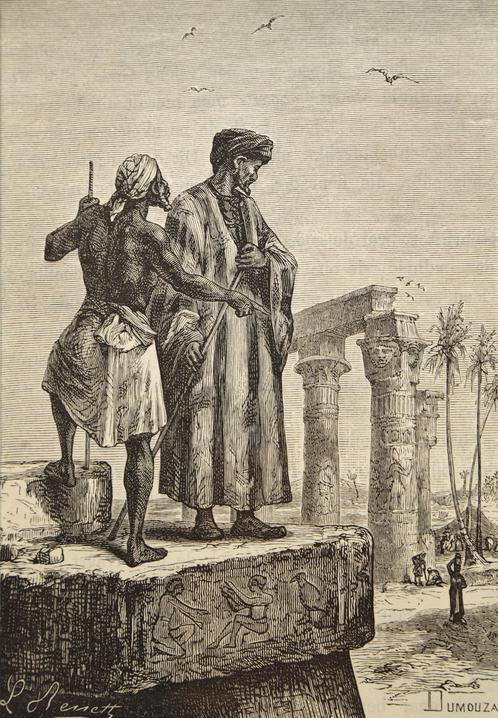
Ibn Battuta was a 14th-century Moroccan explorer who traveled over 120,000 kilometers (approximately 75,000 miles), covering more distance than any other individual in the pre-modern world. Setting out from Tangier in 1325 at the age of twenty-one on a pilgrimage to Mecca, he spent the next three decades traversing Africa, the Middle East, Central Asia, India, Southeast Asia, and China. His journeys documented the vast connectivity of the Islamic world (Dar al-Islam), a realm in which a shared faith, legal system, and language of scholarship allowed a traveler to find hospitality and employment across an enormous geographic range. His journals, compiled into the Rihla ("The Travels"), provide an invaluable primary source for understanding the cultural, religious, commercial, and urban geography of the medieval era. His account reveals that the Islamic world of the fourteenth century was far more interconnected than contemporary Europe.
Trace his global journey →Human Geography: Cultural Hearths and Oil Wealth
This region is a primary Cultural Hearth, the birthplace of urban life, writing, agriculture, and the three major monotheistic religions: Judaism, Christianity, and Islam. The cultural landscape is marked by sacred sites, historic bazaars, and modern skyscrapers, reflecting layers of human activity stretching back more than ten thousand years. Understanding this deep history is essential to interpreting the political conflicts, social structures, and economic patterns that define the region today.

Cradle of Civilization and Cultural Hearth
The Fertile Crescent, an arc of relatively well-watered land stretching from the Persian Gulf through Mesopotamia and down the eastern Mediterranean coast, is widely recognized as one of humanity's earliest centers of innovation. It was here, roughly 10,000 years ago, that humans first domesticated wheat, barley, sheep, goats, and cattle, initiating the Neolithic Revolution, the transition from nomadic hunting and gathering to settled agriculture. This shift had profound geographic consequences: food surpluses enabled population growth, labor specialization, and the emergence of the first cities.
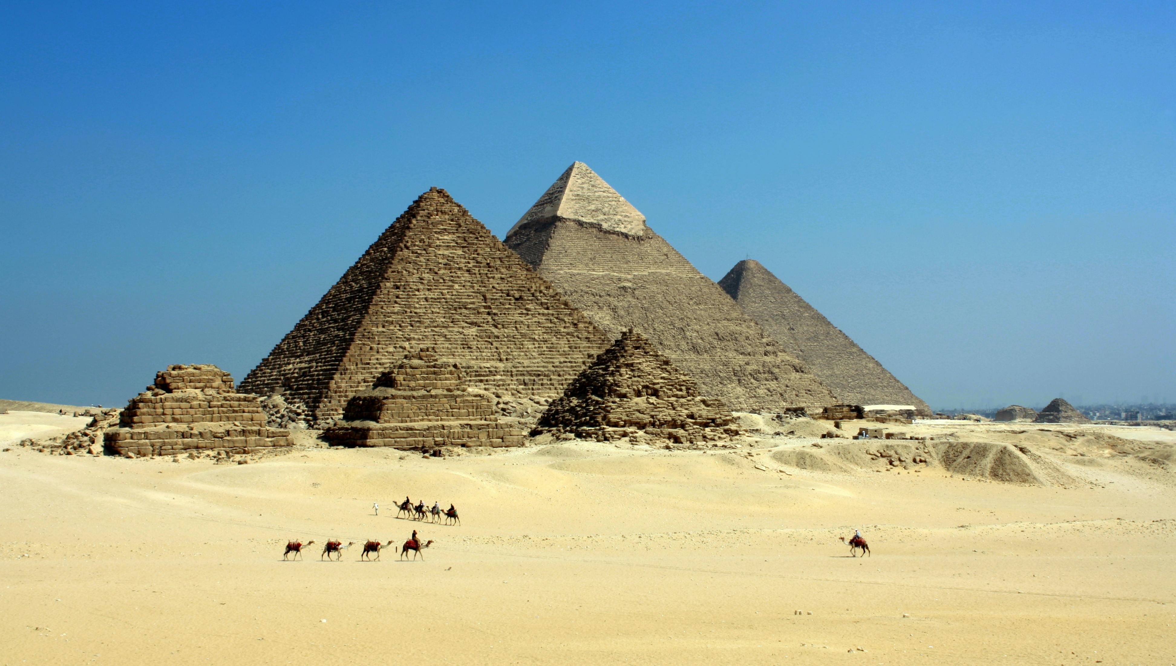
Mesopotamia, the "land between rivers," gave rise to a succession of remarkable civilizations, including the Sumerians, Akkadians, Babylonians, and Assyrians. The Sumerians, who flourished around 3500 BCE, are credited with inventing cuneiform writing, the wheel, the plow, and the concept of the city-state. Babylon, under King Hammurabi (reigning circa 1792 to 1750 BCE), produced one of the earliest written legal codes. Meanwhile, the Nile Valley civilization of Egypt developed independently, producing its own system of writing (hieroglyphics), monumental architecture (the pyramids of Giza), and a centralized state structure that persisted for over three thousand years. These two cultural hearths, Mesopotamia and the Nile Valley, provided the foundations for much of Western civilization's legal, literary, scientific, and religious traditions.
Three Monotheistic Religions
The MENA region is the birthplace of the world's three major monotheistic religions, all of which trace their spiritual lineage to the patriarch Abraham. Judaism, the oldest of the three, emerged in the Levant (present-day Israel and Palestine) roughly 3,500 years ago. Its sacred texts, including the Torah, established ethical monotheism and a covenant between God and the Jewish people tied to a specific geographic territory, the "Promised Land." Jerusalem, with its Western Wall and Temple Mount, remains the holiest city in Judaism.
Christianity emerged from within Judaism in the first century CE, founded on the teachings of Jesus of Nazareth, whom Christians believe to be the Messiah. Christianity spread rapidly through the Roman Empire via both expansion diffusion (person to person) and hierarchical diffusion (adoption by Emperor Constantine in the fourth century). Jerusalem, Bethlehem, and Nazareth remain sacred sites for Christians worldwide.
Islam, the youngest and now the second-largest religion globally with approximately 1.8 billion followers, was founded by the Prophet Muhammad in the seventh century CE. Born in Mecca around 571 CE, Muhammad received divine revelations that were compiled into the Quran. Islam spread rapidly through both trade networks and military conquest, and within a century of Muhammad's death in 632 CE, it had expanded from the Iberian Peninsula to Central Asia. The religion is structured around the Five Pillars: the declaration of faith (Shahadah), prayer five times daily (Salat), charitable giving (Zakat), fasting during Ramadan (Sawm), and pilgrimage to Mecca (Hajj). Islam divided into two primary branches, Sunni (approximately 85 percent of Muslims) and Shia (approximately 15 percent), following a succession dispute after Muhammad's death. This division remains a major source of geopolitical tension, particularly between Sunni-majority Saudi Arabia and Shia-majority Iran.
Colonial Legacy and Modern Borders
The political map of the modern MENA region is largely a product of European colonial intervention in the twentieth century. For over four hundred years (1517 to 1922), the Ottoman Empire governed much of the region, including present-day Turkey, Syria, Iraq, Lebanon, Jordan, Israel/Palestine, Egypt, and parts of the Arabian Peninsula. The Ottoman system organized populations by religious community (the millet system) rather than by ethnicity or nationality, allowing diverse groups to coexist under a single imperial administration.
The collapse of the Ottoman Empire after World War I created a power vacuum that Britain and France filled through the mandate system, authorized by the League of Nations. The infamous Sykes-Picot Agreement of 1916, a secret Anglo-French accord, drew straight-line borders through the former Ottoman territories with little regard for ethnic, tribal, or religious boundaries. France received mandates over Syria and Lebanon; Britain received mandates over Iraq, Jordan (then Transjordan), and Palestine. These arbitrary borders grouped together populations that had little shared identity (as in Iraq, which combined Sunni Arabs, Shia Arabs, and Kurds) while dividing others (such as the Kurds, who were split among Turkey, Iraq, Iran, and Syria). The consequences of these decisions continue to drive conflict across the region, as states struggle to build national cohesion across boundaries that were imposed from the outside.
The Arab Spring and Political Geography
In December 2010, a Tunisian street vendor named Mohamed Bouazizi set himself on fire to protest government corruption and economic hopelessness, sparking a wave of protests that swept across the Arab world in what became known as the Arab Spring. The underlying geographic factors that fueled these uprisings included rapid urbanization, a "youth bulge" (large cohorts of unemployed young people), rising food prices driven partly by global commodity markets, and decades of authoritarian governance.
Tunisia's president, who had held power for twenty-three years, was the first to fall, fleeing to Saudi Arabia in January 2011. In Egypt, millions of demonstrators occupied Tahrir Square in Cairo, forcing President Hosni Mubarak from power after nearly thirty years. Libya descended into armed revolution and civil war, resulting in the overthrow and death of Muammar Gadhafi, who had ruled for forty-two years. Yemen experienced prolonged conflict between government forces and opposition factions. The most devastating outcome occurred in Syria, where peaceful protests against President Bashar al-Assad escalated into a multi-sided civil war that has killed hundreds of thousands, displaced millions (creating the largest refugee crisis since World War II), and drawn in regional and global powers including Russia, Iran, Turkey, and the United States. Bahrain's protests were suppressed with military assistance from Saudi Arabia. Only Tunisia has transitioned to a functioning, if fragile, democracy, illustrating how deeply entrenched authoritarian structures can be and how geographic factors (oil wealth, sectarian divisions, external intervention) can shape political outcomes.
Oil Wealth and Development Disparities
The distribution of oil wealth across the MENA region has created some of the most extreme development disparities on Earth. Geographers and political scientists use the concept of the rentier state to describe governments that derive a substantial portion of their revenue from external rents (primarily oil and gas exports) rather than from domestic taxation. In a rentier state, the social contract between government and citizens is fundamentally different: rather than taxing citizens and providing services in return, the government distributes resource wealth in exchange for political loyalty. Saudi Arabia, Kuwait, Qatar, the UAE, and Bahrain all exhibit characteristics of rentier states, offering their citizens free education, healthcare, subsidized housing, and no income tax.
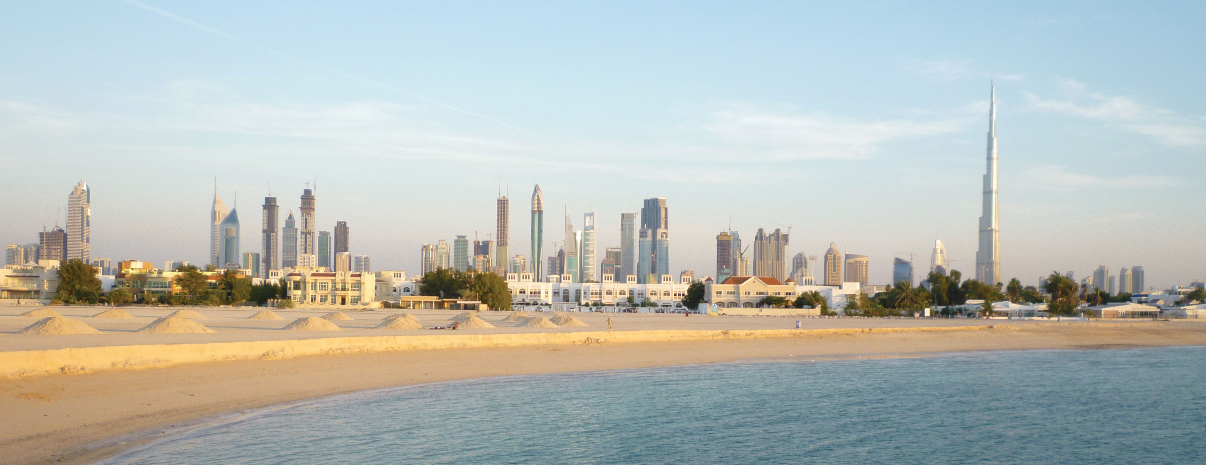
This model has produced remarkable material transformation. Dubai, part of the UAE, was a small fishing and pearl-diving village in the 1960s; today it boasts the world's tallest building (Burj Khalifa), massive artificial islands, and a population that is roughly 85 percent foreign-born migrant workers. Qatar has the highest per capita GDP in the world. Yet the rentier model also produces vulnerabilities: dependence on a single commodity, suppression of political participation, heavy reliance on imported labor (often under exploitative conditions), and difficulty diversifying economies.
In stark contrast, countries without significant oil reserves, such as Yemen, Jordan, and Egypt, face chronic unemployment, underfunded public services, and dependence on foreign aid. Yemen, the poorest country on the Arabian Peninsula, has a per capita GDP roughly one-fiftieth that of Qatar. This disparity is not simply a matter of geological luck; it reflects how colonial borders, governance structures, and global commodity markets interact with physical geography to produce radically different human outcomes across short distances.
The Resource Curse Paradox
Economists have observed that many resource-rich developing nations actually perform worse on measures of governance, economic growth, and social development than resource-poor nations. This paradox, known as the "resource curse" or the "paradox of plenty," suggests that abundant natural resources can weaken institutions, fuel corruption, and reduce incentives for economic diversification. Iraq and Libya, both possessing massive oil reserves, have experienced decades of conflict, authoritarianism, and underdevelopment. The Gulf monarchies, by contrast, have managed their resource wealth more effectively, though critics argue this has come at the cost of political freedom and labor rights.
Data Exploration: Oil Production vs. Human Development
Does oil wealth translate into human development? Compare oil production (barrels per day, in millions) against Human Development Index (HDI) scores for selected MENA nations. The relationship is more complex than you might expect, revealing the "resource curse" paradox where some of the world's richest oil producers have surprisingly low human development scores.
Interpretation: Notice that the UAE and Qatar have high oil production AND high HDI, while Iraq and Libya have high production but lower HDI. Yemen, with minimal oil, has the lowest HDI in the region. What geographic, political, and historical factors explain why oil wealth benefits some populations more than others?
Water Wars: The Nile, the Euphrates, and the Politics of Water Scarcity
Water scarcity is not merely an environmental challenge in the MENA region; it is a source of geopolitical conflict that has the potential to reshape international relations. Two river systems illustrate this dynamic with particular clarity.
The Nile River is shared by eleven nations, but Egypt and Ethiopia are locked in the most consequential dispute. Ethiopia's construction of the Grand Ethiopian Renaissance Dam (GERD), the largest hydroelectric project in Africa, has created a diplomatic crisis. Ethiopia argues that the dam is essential to provide electricity to the 60 percent of its population that lacks access to power, and that it has a sovereign right to develop resources within its own borders. Egypt counters that it depends on the Nile for 97 percent of its freshwater supply and that any significant reduction in flow could be catastrophic for its agriculture and its population of over 100 million. Sudan, positioned between the two, faces complex trade-offs: the dam could regulate flooding and provide cheap electricity, but Sudan also depends on Nile water for its own agriculture.
In the Tigris-Euphrates basin, Turkey's Southeastern Anatolia Project (GAP) has constructed over twenty dams on the upper Tigris and Euphrates, dramatically reducing water flow to downstream Syria and Iraq. The Ataturk Dam alone has a reservoir capacity equal to the total annual discharge of the Euphrates River. As climate change reduces precipitation in the headwater regions, these upstream-downstream conflicts will intensify, potentially threatening food security for hundreds of millions of people.
Questions to Consider:
- Is the Nile a formal, functional, or perceptual region? How does your classification change depending on perspective (Egyptian vs. Ethiopian)?
- How do "upstream" and "downstream" geographic positions translate into political power? Is the upstream nation always advantaged?
- How might climate change alter the balance of power in transboundary water disputes? What role should international law play in governing shared water resources?
- Arab Spring
- A wave of pro-democracy protests and uprisings that swept across the MENA region beginning in late 2010, resulting in the overthrow of several authoritarian governments.
- Chokepoint
- A narrow strategic waterway through which large volumes of international shipping must pass, such as the Strait of Hormuz or the Suez Canal.
- Cultural Hearth
- A region or area where an early human civilization began and from which cultural traits, technologies, and ideas diffused outward to other regions.
- Desalination
- The process of removing salt and other dissolved minerals from seawater or brackish water to produce fresh water suitable for drinking or irrigation.
- Exotic Stream
- A river that originates in a humid region and flows through an arid region, losing volume as it progresses toward its mouth rather than gaining tributaries.
- Fertile Crescent
- An arc of relatively well-watered land stretching from the Persian Gulf through Mesopotamia and along the eastern Mediterranean coast, where agriculture and urbanization first developed.
- Maghreb
- The western portion of North Africa, typically including Morocco, Algeria, Tunisia, Libya, and Mauritania; derived from the Arabic word for "west" or "place of sunset."
- Monotheism
- The belief in a single, all-powerful deity; the theological foundation shared by Judaism, Christianity, and Islam.
- OPEC
- The Organization of the Petroleum Exporting Countries, an intergovernmental cartel of oil-producing nations that coordinates production levels to influence global oil prices.
- Qanat
- An ancient underground aqueduct system, originating in Persia, that channels mountain snowmelt to lowland settlements through gravity-fed tunnels.
- Rentier State
- A state that derives a substantial portion of its national revenues from external rents (such as oil or gas exports) rather than from domestic taxation of its citizens.
- Sharia
- Islamic law derived from the Quran, the Hadith (sayings of Muhammad), and scholarly interpretation; applied with varying degrees of strictness across Muslim-majority countries.
- Sunni and Shia
- The two largest branches of Islam, divided by a seventh-century succession dispute. Sunni Muslims (approximately 85 percent) follow elected communal leadership; Shia Muslims (approximately 15 percent) follow a hereditary line of Imams descended from Ali, Muhammad's cousin and son-in-law.
- Sykes-Picot Agreement
- A secret 1916 accord between Britain and France that divided the former Ottoman territories of the Middle East into spheres of influence, establishing borders that persist (with modifications) to this day.
- Aridity as Destiny: The region is characterized by extreme aridity, making water the most strategically contested resource and the primary determinant of settlement patterns.
- Exotic Streams: The Nile, Tigris-Euphrates, and Jordan rivers are exotic streams that sustain entire civilizations in otherwise uninhabitable desert landscapes, creating critical upstream-downstream dependencies.
- Cultural Hearth: MENA is a global cultural hearth that gave rise to agriculture, urbanization, writing, and the three major monotheistic religions (Judaism, Christianity, and Islam).
- Strategic Chokepoints: The Suez Canal, Strait of Hormuz, Bab el-Mandeb, and Bosporus are maritime chokepoints that give the region outsized influence over global trade and energy flows.
- Oil and Geopolitics: The region's vast petroleum reserves have shaped its modern political geography, creating rentier states, fueling international intervention, and generating extreme wealth disparities.
- Colonial Borders: The arbitrary borders drawn by European colonial powers (particularly the Sykes-Picot Agreement) created multi-ethnic states with weak national cohesion, contributing to persistent conflict.
- Sunni-Shia Divide: The division between Sunni and Shia Islam, originating in a seventh-century succession dispute, continues to shape political alliances and regional rivalries.
- Arab Spring: The 2011 uprisings demonstrated how geographic factors (urbanization, youth demographics, food prices) interact with political grievances to produce revolutionary change, though outcomes varied dramatically by country.
- Development Disparities: The contrast between oil-rich Gulf states (UAE, Qatar) and oil-poor nations (Yemen, Jordan) illustrates how the resource curse, governance quality, and colonial legacies produce radically different development outcomes within the same region.
Negotiating the Nile: A Water Crisis Summit
The Nile River is the lifeblood of northeastern Africa, but its waters are shared, and contested, by eleven nations. Ethiopia has built the Grand Ethiopian Renaissance Dam (GERD), the largest hydroelectric dam in Africa. Egypt, which depends on the Nile for 97% of its freshwater, sees this as an existential threat. You are attending an emergency summit to negotiate a water-sharing agreement.
Role A: Egypt
Your 100 million people depend almost entirely on the Nile. You demand guaranteed minimum water flows and veto power over dam operations during droughts. You consider this a matter of national survival and point to colonial-era treaties granting Egypt the majority of Nile water.
Role B: Ethiopia
You are building the dam to provide electricity to 60% of your population who lack power. You argue that upstream nations have the sovereign right to develop their own resources and lift their people out of poverty. You reject colonial-era treaties that were signed without Ethiopian participation.
Role C: Sudan
You are caught between your two neighbors. The dam could actually benefit Sudan by regulating floods and providing cheap electricity, but you fear being pressured by both sides and losing leverage over your own water needs.
Role D: UN Mediator
You must craft a compromise that all parties can accept. You have access to climate data showing the Nile's flow is already declining due to climate change, making the stakes even higher. International law provides no clear framework for resolving transboundary water disputes.
Knowledge Check
Test your understanding of the core concepts covered in this chapter. This quiz consists of multiple-choice questions designed to review key terms, regional patterns, and geographic relationships. Select the best answer for each question to receive immediate feedback.
Loading quiz questions...
Discussion and Reflection Prompts
Reflect on Your Learning
- Water as Power: Why is water described as "the oil of the 21st century" in MENA? How does control over water resources translate into political power between upstream and downstream nations?
- Cultural Hearth: This region gave birth to three major world religions. How does this shared religious heritage both unite and divide the region today? Consider the role of sacred geography (Jerusalem, Mecca, Karbala) in political conflicts.
- Rentier States: How does oil wealth change the relationship between a government and its citizens? What happens to the social contract in a rentier state, and what challenges do these states face when oil revenues eventually decline?
Discuss With Your Peers
- Is desalination a sustainable long-term solution to water scarcity, or does it create new environmental problems (energy consumption, brine discharge, marine habitat destruction)? What role should technology play in solving geographic challenges?
- The Arab Spring showed that geographic factors (urban concentration, youth bulge, food prices, social media access) can trigger political revolutions. Can you identify similar geographic conditions in other world regions that might produce comparable outcomes?
- The Sykes-Picot Agreement drew arbitrary borders through the Middle East over a century ago. How do these colonial-era boundaries continue to shape ethnic conflicts, national identities, and political instability in Iraq, Syria, and other states?
Curriculum Standards Alignment
This chapter aligns with the following National and State geography standards.