At a Glance
At a Glance
Learning Outcomes
- Locate: Major physical regions (Rockies, Great Plains, Canadian Shield).
- Analyze: Urbanization patterns (Megalopolis) and the Sun Belt population shift.
- Explain: The economic integration of USMCA and cross-border supply chains.
- Evaluate: The impact of immigration on cultural diversity and demographics.
- Apply: Geographic concepts to understand the functional integration of the US-Mexico border.
Key Terms
Megalopolis, Sun Belt, Rain Shadow Effect, Maquiladora, USMCA, Gentrification, Functional Region, Rust Belt, Canadian Shield.
Stop & Check
Reveal Answer
Common Misconception
Myth: The US economy is independent and self-sufficient.
Fact: North American economies are deeply integrated. Under the USMCA, a single product (like a car) often crosses the border 7-8 times during assembly before it is finished.
Regional Snapshot: North America at a Glance
North America is defined by its extreme environmental variety and its highly integrated economy. The region contains both the world's largest economy (USA) and one of the world's largest megacities (Mexico City), illustrating the vast scale of human modification of the landscape.
Interactive Map: The Continental Core
Explore the major urban clusters and physical barriers of North America. Zoom in to see the "BosWash" megalopolis, the Texas Triangle, and the vast expanses of the Great Plains.
Toggle between Physical terrain and Political boundaries. Notice how the Mississippi River system and the Great Lakes serve as massive inland waterways for global trade.
Physical Geography: Mountains, Shields, and Plains
North America's physical landscape divides into distinct physiographic regions, each shaping human settlement and economic activity.
Western Mountain Systems
The young, rugged Rocky Mountains form North America's continental backbone, stretching over 4,800 km from New Mexico to Alaska. Glacial sculpting created dramatic peaks exceeding 4,000 meters. West of the Rockies lies the Intermontane Region, high plateaus and basins including the Great Basin, Columbia Plateau, and Colorado Plateau. The Pacific Coast Ranges (Sierra Nevada, Cascades, Coast Ranges) trap moisture from Pacific weather systems, creating the dramatic rain shadow effect.
The Rain Shadow Effect
As Pacific air masses rise over western mountains, moisture condenses and falls as precipitation on windward slopes. The leeward (east) side receives far less rainfall, explaining why Seattle receives 965mm of annual precipitation while Spokane (just 450 km east) receives only 430mm. This effect creates the semiarid Great Plains and desert landscapes of Nevada, Utah, and Arizona.
Eastern Highlands: The Appalachians
The ancient Appalachian Mountains contrast sharply with the Rockies. Formed 480 million years ago, erosion has reduced peaks to under 2,000 meters. Despite their modest elevation, the Appalachians profoundly shaped American history, they formed the first barrier to westward expansion, channeling early settlement along river valleys and creating distinct "mountain culture" communities that persisted into the 20th century.
The Interior Plains
Between the mountain systems lies the continent's agricultural heartland:
- Interior Lowlands: From the Appalachians to the 100th meridian, humid climate, deep soils, the Corn Belt and dairy regions
- Great Plains: West of the 100th meridian, semiarid grasslands, the "breadbasket" producing wheat, cattle ranching, and increasingly wind energy
- Mississippi River System: The continent's drainage backbone, connecting the Great Lakes to the Gulf of Mexico, historically the primary transportation corridor before railroads
Canadian Shield
The Canadian Shield covers roughly half of Canada's land area, an ancient, glacially scoured landscape of exposed bedrock, thin soils, and thousands of lakes. This Precambrian rock (up to 4 billion years old) contains enormous mineral wealth (gold, nickel, copper, uranium) but supports little agriculture. Most Canadians live south of the Shield, concentrated within 200 km of the US border.
Coastal Lowlands
The Gulf-Atlantic Coastal Plain stretches from New York to Texas, a flat, low-lying zone of barrier islands, wetlands, and the Florida peninsula. This region faces increasing vulnerability to hurricanes, sea-level rise, and coastal erosion.
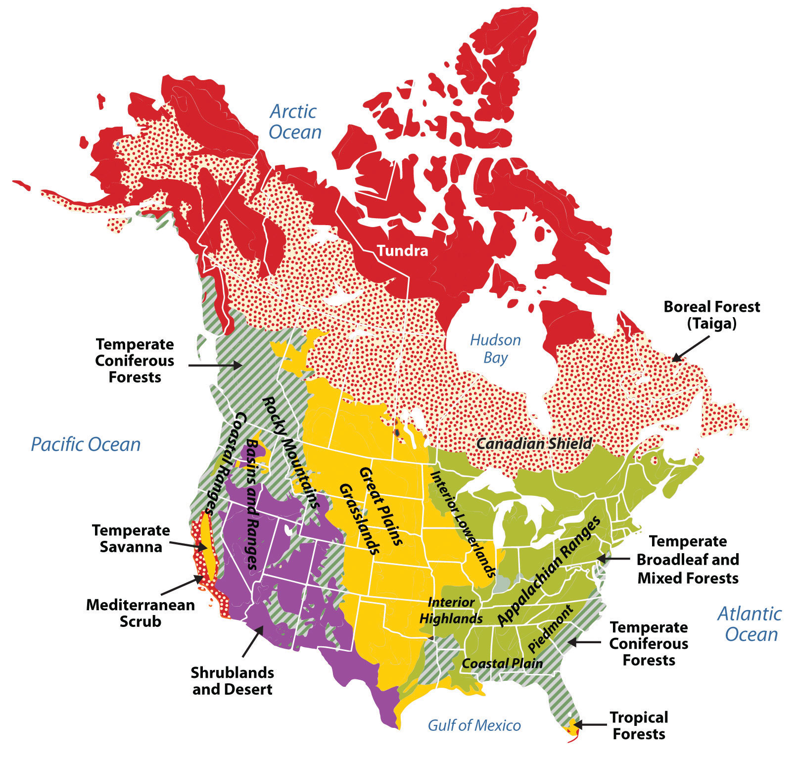
Climate Patterns
Two dominant patterns shape North American climate:
- North-South temperature gradient: From Arctic (Type E tundra) in northern Canada to tropical (Type A) in Florida and Hawaii
- East-West precipitation gradient: Humid conditions in the east (Type C climates) give way to semiarid conditions in the Great Plains (Type B) before increasing again at the Pacific Coast
The climate diversity, frigid tundra, temperate forests, subtropical wetlands, deserts, and rainforests, exists within a single continent, creating extraordinary agricultural and ecological variety.
Geographic Inquiry
The Ogallala Aquifer supports massive irrigation in the Great Plains. As this non-renewable water source is depleted, how will the "agricultural geography" of North America be forced to shift? What regions might benefit? What populations might be displaced?
Data Visualization: North America at a Glance
The following charts illustrate key geographic and economic patterns across the three North American nations. Analyze the data and consider what these numbers reveal about regional inequality and integration.
GDP per Capita (USD, 2024 est.)
Notice the dramatic gap between Mexico and its northern neighbors. How does this economic disparity drive migration and shape the maquiladora economy?
Urbanization Rate (% Urban Population)
All three nations are highly urbanized. What geographic factors (climate, resources, trade routes) explain why cities cluster where they do in each country?
Important Person
Urban Theorist & Activist
Jacobs transformed our understanding of the "human geography" of cities. She argued that vibrant urban life is created by "eyes on the street" and mixed-use neighborhoods, challenging the mid-20th century trend of massive highway construction and urban renewal.
Explore Jacobs's impact on city planning →Colonial History: European Imprint on North America
Before European contact, North America was home to diverse Indigenous peoples, from the Inuit in the Arctic to the Aztec Empire in Mexico. Complex societies including the Iroquois Confederacy, Pueblo communities, and Mississippi mound-builders thrived for millennia. European colonization fundamentally transformed the continent.
Three European Spheres of Influence
Spanish Influence (1500s-1800s)
Territory: Florida, Southwest (California, Arizona, New Mexico, Texas), Mexico
-
St. Augustine Fort: Castillo de San Marcos represents the oldest permanent European settlement in North America. - St. Augustine, Florida (1565), oldest permanent European settlement in North America
- Mission system spread Catholicism and Spanish language across the Southwest
- Lasting legacy: Place names (San Francisco, Los Angeles, San Antonio), architecture, Hispanic culture throughout the Sun Belt
French Influence (1600s-1763)
Territory: Quebec, Great Lakes, Mississippi River Valley (Louisiana Territory)
- Focused on fur trade rather than large-scale settlement
- French place names remain: Detroit ("strait"), Baton Rouge ("red stick"), Des Moines, Louisiana
- Long-lot land survey system still visible along the St. Lawrence and in Louisiana
- Lasting legacy: French-speaking Quebec (7+ million people), Cajun culture in Louisiana, bilingual Canada
British Influence (1607-1776+)
Territory: Eastern seaboard (13 colonies), eventually most of Canada
- Jamestown, Virginia (1607), first permanent English settlement
- Large-scale agricultural settlement and demographic dominance
- English common law, Protestant Christianity, parliamentary government
- Lasting legacy: English language dominance, political institutions, cultural values across most of US and Canada
Why English Dominates
Despite Spain and France arriving earlier, British settlement patterns emphasized permanent agricultural colonies with entire families, while Spanish and French colonization relied more on missionaries, traders, and soldiers. By 1776, British colonies had over 2.5 million settlers, far outnumbering Spanish and French populations combined.
Human Geography: Urbanization and Integration
North America is one of the world's most urbanized regions, with approximately 82% of the population living in metropolitan areas. The United States has over 330 million people; Canada has 40 million; and Mexico has 130 million.
The Rise of the Megalopolis
Geographer Jean Gottmann coined the term Megalopolis in 1961 to describe the nearly continuous urban corridor from Boston to Washington, D.C., often called "BosWash." This concept of interconnected metropolitan areas now applies to other regions:
- BosWash Corridor: Boston-New York-Philadelphia-Baltimore-Washington, D.C. (50+ million people)
- Great Lakes Megalopolis: Chicago-Detroit-Cleveland-Pittsburgh-Toronto
- Texas Triangle: Dallas-Houston-San Antonio-Austin (fastest-growing US megaregion)
- Pacific Coast: San Diego-Los Angeles-San Francisco-Seattle-Vancouver
- Mexico City Metropolitan Area: 21+ million people, one of the world's largest urban agglomerations
Population Distribution and Migration
Population distribution reveals distinct geographic patterns:
- Canada: 90% of Canadians live within 200 km of the US border; Ontario is often called "South Canada" for its southern extension
- United States: Historic population shift from Northeast/Midwest to Sun Belt (South and Southwest)
- Mexico: Concentration on the Central Plateau (altiplano) around Mexico City, with growth in northern border cities
The Sun Belt Shift
Since 1970, the US population center has moved steadily southwest. Three states, California, Texas, and Florida, account for nearly one-third of US population growth. Factors include:
- Air conditioning making hot climates habitable year-round
- Retirement migration (Florida, Arizona)
- Technology sector growth (Texas, California)
- Lower cost of living compared to Northeast
- Immigration from Latin America (Texas, California, Florida)
Immigration and Cultural Diversity
Immigration has reshaped North American demographics throughout history, and continues to do so:
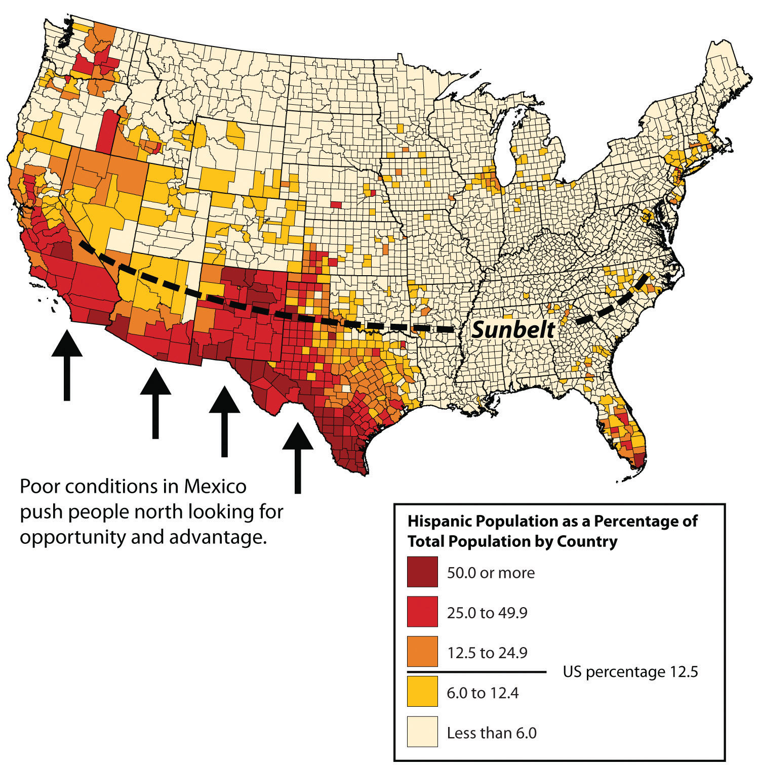
- Hispanic/Latino population: Now 62+ million in the US (nearly 19%), with particularly high concentrations in California, Texas, Florida, and the Southwest
- Asian American population: Fastest-growing demographic group, concentrated in California, New York, and Texas
- Canadian multiculturalism: Official policy since 1971; Toronto is one of the world's most diverse cities

Economic Integration: USMCA
The USMCA (United States-Mexico-Canada Agreement, 2020) replaced NAFTA and governs the world's largest free trade zone by GDP. Key features:
- Integrated manufacturing: A single automobile may cross the US-Mexico border 8+ times during production
- Agricultural trade: US exports corn and wheat to Mexico; imports fruits, vegetables, and avocados
- Energy integration: Cross-border pipelines and electricity transmission
- Services and digital trade: New provisions for e-commerce and intellectual property
This creates a massive functional region, an area defined by economic activity rather than political boundaries.
Geographic Inquiry: Immigration and Identity
The United States is often called a "nation of immigrants." Yet immigration policy remains deeply contested. Using geographic thinking: How does the spatial distribution of immigrant communities shape local economies and cultures? Is the "melting pot" or "cultural mosaic" model a better description of North American multiculturalism, and does it vary by city or region?
The US-Mexico Border: Integration and Division
The 2,000-mile border between the US and Mexico is a study in contradictions. It is one of the most economically integrated boundaries in the world, with cities like El Paso-Juarez functioning as a single "binational" metropolitan area. Yet, it remains a site of intense political division regarding migration and security.
Economic Integration
Over $700 billion in goods cross the US-Mexico border annually, more trade than crosses the US-China border. The border region hosts over 3,000 maquiladoras, assembly plants that import components duty-free, add value through manufacturing, and export finished products. Major industries include automotive, electronics, medical devices, and aerospace.
Migration Dynamics
The border has seen multiple migration patterns:
- Bracero Program (1942-1964): Brought 4.6 million Mexican agricultural workers to the US
- Undocumented immigration peaks: Reached 12.2 million in 2007, has since declined
- Current asylum seekers: Increasing numbers from Central America and globally
- Reverse migration: More Mexicans returned to Mexico than arrived in the US during 2009-2014
Questions to Consider:
- How do Maquiladoras illustrate the functional integration of the border region despite political boundaries?
- In what ways does the border serve as both a "filter" and a "barrier" in global geography?
- How might climate change in Central America affect migration patterns to North America?
- Megalopolis
- A large, continuous urban region formed by the merging of several metropolitan areas. Term coined by Jean Gottmann (1961) to describe the Boston-Washington corridor (BosWash).
- Sun Belt
- The southern and southwestern states experiencing rapid population and economic growth since the 1960s, including Texas, Florida, Arizona, and California.
- Canadian Shield
- The ancient, glacially scoured bedrock core of North America, covering half of Canada. Rich in minerals but unsuitable for agriculture.
- Rain Shadow Effect
- The dry conditions on the leeward (downwind) side of a mountain range, caused when rising air masses release moisture on the windward side.
- Great Plains
- The semiarid grassland region between the Rocky Mountains and the 100th meridian, characterized by wheat farming, cattle ranching, and wind energy production.
- Maquiladora
- A foreign-owned factory in Mexico, typically near the US border, where imported components are assembled by workers into products for export. Enabled by NAFTA/USMCA free trade provisions.
- USMCA
- The United States-Mexico-Canada Agreement (2020), a free trade agreement that replaced NAFTA, governing trade relations among the three North American nations.
- Functional Region
- A geographic area organized around a node or focal point, defined by economic, social, or political activity rather than physical features. Example: commuting zones, trade networks.
- Ogallala Aquifer
- A vast underground water reservoir beneath the Great Plains, providing irrigation for agriculture in eight states. Depletion threatens long-term agricultural viability.
- Intermontane Region
- The area "between mountains", the plateaus, basins, and deserts between the Rocky Mountains and the Pacific Coast ranges (Great Basin, Columbia Plateau, Colorado Plateau).
- Long-Lot Survey System
- A French colonial land division pattern creating long, narrow parcels extending back from rivers or roads. Visible in Quebec and Louisiana.
- Border Cities (Twin Cities)
- Paired urban areas straddling an international boundary, functioning as integrated metropolitan zones. Examples: El Paso-Juarez, San Diego-Tijuana, Detroit-Windsor.
- Gentrification
- The process of wealthier residents moving into urban neighborhoods, renovating housing, and often displacing lower-income residents.
- Rust Belt
- The formerly industrialized region of the Great Lakes and northeastern US, characterized by deindustrialization and population decline since the 1970s.
- Physiographic diversity: North America's landforms, from young western mountains to ancient eastern highlands to interior plains, create distinct economic regions and settlement patterns.
- Climate gradients: Temperature decreases north to south; precipitation decreases east to west until the Pacific Coast. The rain shadow effect shapes agriculture and settlement across the western half of the continent.
- Colonial legacy: Spanish, French, and British colonization left lasting imprints on language, religion, law, and settlement patterns. British demographic dominance explains English language prevalence.
- Highly urbanized: Over 80% of North Americans live in metropolitan areas, with megalopolitan corridors emerging along both coasts and in Texas.
- Population shift: The Sun Belt states (South and Southwest) have gained population while the Rust Belt (Midwest/Northeast) has declined, driven by air conditioning, retirement migration, and economic restructuring.
- Immigration reshapes demographics: Hispanic/Latino and Asian populations are the fastest-growing demographic groups, transforming cultural geography particularly in border states and gateway cities.
- Economic integration: USMCA creates a single continental market where manufactured goods cross borders multiple times during production, a functional region transcending political boundaries.
- Border paradox: The US-Mexico border simultaneously represents deep economic integration (maquiladoras, cross-border trade) and political tension over migration and security.
- Environmental challenges: Water scarcity (Ogallala Aquifer depletion), coastal vulnerability (hurricanes, sea-level rise), and urbanization pressures present ongoing geographic challenges.
Regional Decisions: The Great Plains Water Crisis
The Ogallala Aquifer is being depleted at a rate far exceeding natural recharge. At current usage rates, significant portions could be exhausted within 25-50 years. You are a member of a Tri-State Water Policy Commission representing Kansas, Nebraska, and Texas. Your task: develop a water management policy that balances agricultural needs, economic survival, and long-term sustainability.
Your family has farmed this land for 4 generations. Irrigation is essential, without it, you lose your livelihood. You fear any restrictions will force you to sell.
Your city depends on the aquifer for drinking water. Population is growing. You need long-term water security for residents, not just agriculture.
The data is clear: current extraction is unsustainable. You advocate for immediate 30% reduction in pumping and investment in drip irrigation technology.
Agriculture contributes $25 billion annually to the regional economy. You must weigh short-term economic pain against long-term collapse. What's the cost-benefit of conservation?
- What policy would your role advocate for? What compromises might you accept?
- How does the geography of the aquifer (spanning multiple states) complicate governance?
- Compare this water crisis to similar challenges in South Asia (monsoon dependence) or the Middle East (water scarcity). What can North America learn?
Knowledge Check
Test your understanding of the core concepts covered in this chapter. This quiz consists of multiple-choice questions designed to review key terms, regional patterns, and geographic relationships. Select the best answer for each question to receive immediate feedback.
Loading quiz questions...
Discussion and Reflection Prompts
Use these prompts to deepen your understanding and connect chapter concepts to your own experience and the broader world.
Reflect on Your Learning
- Think about the place where you grew up or currently live. What physiographic region is it in? How has the physical geography (climate, terrain, water) shaped the local economy and culture?
- The Sun Belt shift has transformed American demographics. Has your community experienced population growth or decline? What geographic factors explain this trend?
- How does your daily life connect to the USMCA trade network? Think about the food you eat, the car you drive, or the electronics you use: where were they made, and what borders did they cross?
Discuss With Your Peers
- "The border is both a wall and a bridge." Do you agree with this statement about the US-Mexico border? Use specific geographic evidence to support your position.
- Canada officially embraces multiculturalism as national policy, while the US has historically promoted a "melting pot" ideal. Which model do you think better serves a diverse society, and why?
- If the Ogallala Aquifer is depleted, which regions of the US would be most affected? Who should bear the cost of conservation: farmers, consumers, or governments?
Curriculum Standards Alignment
This chapter aligns with the following National and State geography standards.